
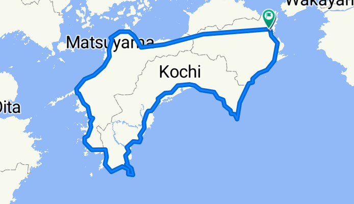
Tour de Shikoku
A cycling route starting in Tokushima, Tokushima, Japan.
Overview
About this route
- -:--
- Duration
- 792.2 km
- Distance
- 1,500 m
- Ascent
- 1,503 m
- Descent
- ---
- Avg. speed
- ---
- Max. altitude
Continue with Bikemap
Use, edit, or download this cycling route
You would like to ride Tour de Shikoku or customize it for your own trip? Here is what you can do with this Bikemap route:
Free features
- Save this route as favorite or in collections
- Copy & plan your own version of this route
- Split it into stages to create a multi-day tour
- Sync your route with Garmin or Wahoo
Premium features
Free trial for 3 days, or one-time payment. More about Bikemap Premium.
- Navigate this route on iOS & Android
- Export a GPX / KML file of this route
- Create your custom printout (try it for free)
- Download this route for offline navigation
Discover more Premium features.
Get Bikemap PremiumFrom our community
Other popular routes starting in Tokushima
 德島Tokushima-室戶Muroto P-D2
- Distance
- 129.9 km
- Ascent
- 894 m
- Descent
- 890 m
- Location
- Tokushima, Tokushima, Japan
 Day 1 - 1
- Distance
- 37.8 km
- Ascent
- 8 m
- Descent
- 18 m
- Location
- Tokushima, Tokushima, Japan
 Tour de Shikoku
- Distance
- 792.2 km
- Ascent
- 1,500 m
- Descent
- 1,503 m
- Location
- Tokushima, Tokushima, Japan
 Around Shikoku 2024
- Distance
- 930.7 km
- Ascent
- 11,371 m
- Descent
- 11,342 m
- Location
- Tokushima, Tokushima, Japan
 4guo
4guo- Distance
- 991.3 km
- Ascent
- 1,801 m
- Descent
- 1,800 m
- Location
- Tokushima, Tokushima, Japan
 2023 2 Tokushima to Takamatsu
- Distance
- 73 km
- Ascent
- 729 m
- Descent
- 725 m
- Location
- Tokushima, Tokushima, Japan
 Tokushima - Nagasaki
- Distance
- 1,455.9 km
- Ascent
- 2,865 m
- Descent
- 2,867 m
- Location
- Tokushima, Tokushima, Japan
 number 19
- Distance
- 90.2 km
- Ascent
- 526 m
- Descent
- 526 m
- Location
- Tokushima, Tokushima, Japan
Open it in the app