

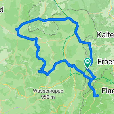
Zum Dreiländereck
A cycling route starting in Frankenheim, Free State of Thuringia, Germany.
Overview
About this route
MTB-Tour zum Dreiländereck (Hessen, Thüringen und Bayern), Rückfahrt auf dem Milseburgradweg (ehemalige Bahntrasse)
- -:--
- Duration
- 72.7 km
- Distance
- 650 m
- Ascent
- 1,023 m
- Descent
- ---
- Avg. speed
- 810 m
- Max. altitude
Route quality
Waytypes & surfaces along the route
Waytypes
Busy road
22.3 km
(31 %)
Track
16.2 km
(22 %)
Surfaces
Paved
50.2 km
(69 %)
Unpaved
6.4 km
(9 %)
Asphalt
44.8 km
(62 %)
Paved (undefined)
4.5 km
(6 %)
Continue with Bikemap
Use, edit, or download this cycling route
You would like to ride Zum Dreiländereck or customize it for your own trip? Here is what you can do with this Bikemap route:
Free features
- Save this route as favorite or in collections
- Copy & plan your own version of this route
- Sync your route with Garmin or Wahoo
Premium features
Free trial for 3 days, or one-time payment. More about Bikemap Premium.
- Navigate this route on iOS & Android
- Export a GPX / KML file of this route
- Create your custom printout (try it for free)
- Download this route for offline navigation
Discover more Premium features.
Get Bikemap PremiumFrom our community
Other popular routes starting in Frankenheim
 Oberhoftour 4-Tagesvariante 2. Eisenacher Hs - Oberhof, entschärft
- Distance
- 65.3 km
- Ascent
- 969 m
- Descent
- 1,085 m
- Location
- Frankenheim, Free State of Thuringia, Germany
 Angerweg 15, Frankenheim/Rhön nach Dermbach, Regelschule
- Distance
- 26.8 km
- Ascent
- 120 m
- Descent
- 499 m
- Location
- Frankenheim, Free State of Thuringia, Germany
 Rhön - Einrolltour Sennhütte
- Distance
- 33.4 km
- Ascent
- 582 m
- Descent
- 582 m
- Location
- Frankenheim, Free State of Thuringia, Germany
 Test Röhn2
- Distance
- 52.2 km
- Ascent
- 379 m
- Descent
- 748 m
- Location
- Frankenheim, Free State of Thuringia, Germany
 Sommertour 2021 Hessen-NRW
- Distance
- 374.5 km
- Ascent
- 3,529 m
- Descent
- 4,269 m
- Location
- Frankenheim, Free State of Thuringia, Germany
 EuroVelo 13 Iron Curtain - Part 10: Frankenheim to Willmars
- Distance
- 20 km
- Ascent
- 603 m
- Descent
- 194 m
- Location
- Frankenheim, Free State of Thuringia, Germany
 stage 4
- Distance
- 50.4 km
- Ascent
- 212 m
- Descent
- 731 m
- Location
- Frankenheim, Free State of Thuringia, Germany
 Zum Dreiländereck
- Distance
- 72.7 km
- Ascent
- 650 m
- Descent
- 1,023 m
- Location
- Frankenheim, Free State of Thuringia, Germany
Open it in the app