

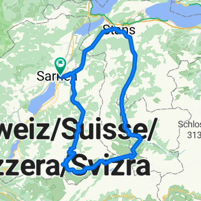
Sarnen-Melchsee wildtour
A cycling route starting in Sarnen, Canton of Obwalden, Switzerland.
Overview
About this route
Die Route mag auf den ersten Blick als nicht möglich erscheinen allerdings befindet sich im gesamten Melchsee gebiet auf Wanderwegen. Allerdings muss man das Velo einige male tragen um den Aufstieg zu schaffen. Ab einem gewissem punkt fährt man dann auf den Skipisten des frutt Gebietes. Es ist zu berücksichtigen das bis Ende Mai Anfang Juni Schnee liegen kann, was die route erschweren oder sogar unmöglich machen kann. Fahrtechnisch ist die route sicherlich Anspruchsvoll aber machbar. Jedoch sollte man Schwindelfrei sein um die besondere Aussicht genießen zu können.
- -:--
- Duration
- 53 km
- Distance
- 1,678 m
- Ascent
- 1,674 m
- Descent
- ---
- Avg. speed
- ---
- Avg. speed
Continue with Bikemap
Use, edit, or download this cycling route
You would like to ride Sarnen-Melchsee wildtour or customize it for your own trip? Here is what you can do with this Bikemap route:
Free features
- Save this route as favorite or in collections
- Copy & plan your own version of this route
- Sync your route with Garmin or Wahoo
Premium features
Free trial for 3 days, or one-time payment. More about Bikemap Premium.
- Navigate this route on iOS & Android
- Export a GPX / KML file of this route
- Create your custom printout (try it for free)
- Download this route for offline navigation
Discover more Premium features.
Get Bikemap PremiumFrom our community
Other popular routes starting in Sarnen
 Sarnen, Ei nach Sarnen, Ei
- Distance
- 19.4 km
- Ascent
- 141 m
- Descent
- 131 m
- Location
- Sarnen, Canton of Obwalden, Switzerland
 Sportliche Route in Sarnen-Alpnach
- Distance
- 6.3 km
- Ascent
- 245 m
- Descent
- 175 m
- Location
- Sarnen, Canton of Obwalden, Switzerland
 Sarnersee-Giswil-FlüeliRanft
- Distance
- 33.5 km
- Ascent
- 795 m
- Descent
- 792 m
- Location
- Sarnen, Canton of Obwalden, Switzerland
 Over Älggi to Melchsee
- Distance
- 71.6 km
- Ascent
- 2,434 m
- Descent
- 2,406 m
- Location
- Sarnen, Canton of Obwalden, Switzerland
 Scheidegg
- Distance
- 132.6 km
- Ascent
- 2,362 m
- Descent
- 2,350 m
- Location
- Sarnen, Canton of Obwalden, Switzerland
 Sarnen - Thun
- Distance
- 73.5 km
- Ascent
- 1,328 m
- Descent
- 1,234 m
- Location
- Sarnen, Canton of Obwalden, Switzerland
 Gerade Fahrt in Sarnen
- Distance
- 31.9 km
- Ascent
- 305 m
- Descent
- 306 m
- Location
- Sarnen, Canton of Obwalden, Switzerland
 Tour deluxe
- Distance
- 70.3 km
- Ascent
- 2,111 m
- Descent
- 2,110 m
- Location
- Sarnen, Canton of Obwalden, Switzerland
Open it in the app