
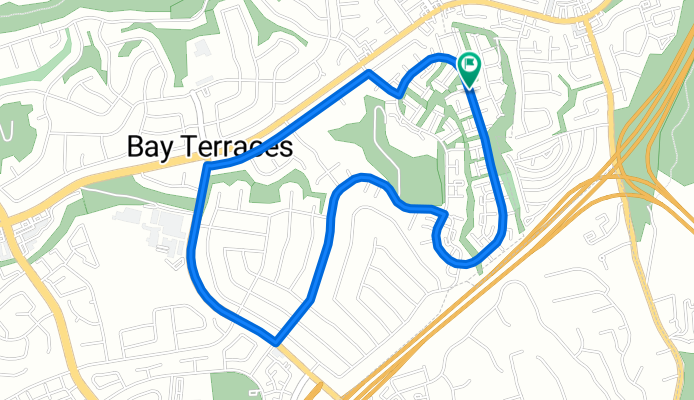
manzana way training circle
A cycling route starting in La Presa, California, United States.
Overview
About this route
instructions
1.park your car on manzana way,
-
get your ass on the bike
-
ride circle clockwise
first hill on goode st
2nd hill on briarwood rd
good luck!
- -:--
- Duration
- 5 km
- Distance
- 119 m
- Ascent
- 119 m
- Descent
- ---
- Avg. speed
- ---
- Max. altitude
Route quality
Waytypes & surfaces along the route
Waytypes
Quiet road
4 km
(80 %)
Undefined
1 km
(20 %)
Surfaces
Paved
3.3 km
(66 %)
Asphalt
3.3 km
(66 %)
Undefined
1.7 km
(34 %)
Continue with Bikemap
Use, edit, or download this cycling route
You would like to ride manzana way training circle or customize it for your own trip? Here is what you can do with this Bikemap route:
Free features
- Save this route as favorite or in collections
- Copy & plan your own version of this route
- Sync your route with Garmin or Wahoo
Premium features
Free trial for 3 days, or one-time payment. More about Bikemap Premium.
- Navigate this route on iOS & Android
- Export a GPX / KML file of this route
- Create your custom printout (try it for free)
- Download this route for offline navigation
Discover more Premium features.
Get Bikemap PremiumFrom our community
Other popular routes starting in La Presa
 manzana way training circle
- Distance
- 5 km
- Ascent
- 119 m
- Descent
- 119 m
- Location
- La Presa, California, United States
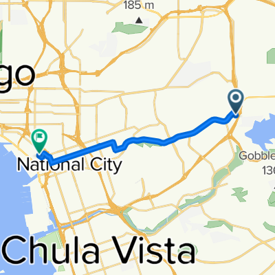 8535 Paradise Valley Rd, Spring Valley to 3730 Norman Scott Rd, San Diego
- Distance
- 11.1 km
- Ascent
- 71 m
- Descent
- 175 m
- Location
- La Presa, California, United States
 1st half of cycle eastlake poker route 2016
- Distance
- 17 km
- Ascent
- 113 m
- Descent
- 173 m
- Location
- La Presa, California, United States
 Glencoe Drive 724, San Diego to Glencoe Drive 724, San Diego
- Distance
- 21.8 km
- Ascent
- 176 m
- Descent
- 178 m
- Location
- La Presa, California, United States
 San D flat route
- Distance
- 67.5 km
- Ascent
- 380 m
- Descent
- 377 m
- Location
- La Presa, California, United States
 8737–8899 Spring Canyon Dr, Spring Valley to 6491 Imperial Ave, San Diego
- Distance
- 7.5 km
- Ascent
- 213 m
- Descent
- 226 m
- Location
- La Presa, California, United States
 Slow ride in Chula Vista
- Distance
- 18.5 km
- Ascent
- 241 m
- Descent
- 243 m
- Location
- La Presa, California, United States
 Spring Valley for Beginners
- Distance
- 16.7 km
- Ascent
- 178 m
- Descent
- 180 m
- Location
- La Presa, California, United States
Open it in the app