

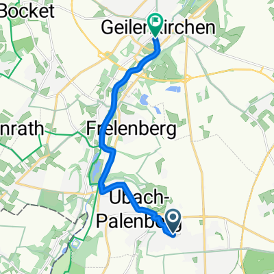
Gangelt Freiband und zurück !
A cycling route starting in Übach-Palenberg, North Rhine-Westphalia, Germany.
Overview
About this route
The route starts from Gillrath along the Rodebach and you can even ride very far towards the Netherlands! This map material doesn't show these paths! The route is approximately 35 kilometers!
- -:--
- Duration
- 11.8 km
- Distance
- 36 m
- Ascent
- 85 m
- Descent
- ---
- Avg. speed
- ---
- Max. altitude
Route quality
Waytypes & surfaces along the route
Waytypes
Track
3.9 km
(33 %)
Road
2.8 km
(24 %)
Surfaces
Paved
6.3 km
(53 %)
Asphalt
6.2 km
(52 %)
Paved (undefined)
0.1 km
(1 %)
Undefined
5.6 km
(47 %)
Route highlights
Points of interest along the route
Point of interest after 0 km
Kath. Pfarrkirche Immendorf
Point of interest after 6.2 km
Beginn der Historischen Bahn Reise
Point of interest after 11.8 km
Kahnweiher Gangelt, Freibad im Sommer ein Magnet, auch ein langer Spaziergang ist möglich !
Continue with Bikemap
Use, edit, or download this cycling route
You would like to ride Gangelt Freiband und zurück ! or customize it for your own trip? Here is what you can do with this Bikemap route:
Free features
- Save this route as favorite or in collections
- Copy & plan your own version of this route
- Sync your route with Garmin or Wahoo
Premium features
Free trial for 3 days, or one-time payment. More about Bikemap Premium.
- Navigate this route on iOS & Android
- Export a GPX / KML file of this route
- Create your custom printout (try it for free)
- Download this route for offline navigation
Discover more Premium features.
Get Bikemap PremiumFrom our community
Other popular routes starting in Übach-Palenberg
 07 Landgraaf - Tienen (102 km)
- Distance
- 102.9 km
- Ascent
- 543 m
- Descent
- 628 m
- Location
- Übach-Palenberg, North Rhine-Westphalia, Germany
 Route in Landgraaf
- Distance
- 51.2 km
- Ascent
- 342 m
- Descent
- 343 m
- Location
- Übach-Palenberg, North Rhine-Westphalia, Germany
 In der Gehölde, Übach-Palenberg nach Schwarzer Weg, Linnich
- Distance
- 17.8 km
- Ascent
- 78 m
- Descent
- 129 m
- Location
- Übach-Palenberg, North Rhine-Westphalia, Germany
 Thornstraße, Übach-Palenberg nach Herzog-Wilhelm-Straße, Geilenkirchen
- Distance
- 7.9 km
- Ascent
- 11 m
- Descent
- 62 m
- Location
- Übach-Palenberg, North Rhine-Westphalia, Germany
 Osterroute-Hendrik-2023-Maastricht_B
- Distance
- 40.5 km
- Ascent
- 310 m
- Descent
- 344 m
- Location
- Übach-Palenberg, North Rhine-Westphalia, Germany
 In der Gehölde, Übach-Palenberg nach Schwarzer Weg, Linnich
- Distance
- 16.5 km
- Ascent
- 50 m
- Descent
- 98 m
- Location
- Übach-Palenberg, North Rhine-Westphalia, Germany
 2. Fahrradtour mit Tom
- Distance
- 21.8 km
- Ascent
- 173 m
- Descent
- 171 m
- Location
- Übach-Palenberg, North Rhine-Westphalia, Germany
 Übach-Palenberg nach Auf der Höhe, Übach-Palenberg
- Distance
- 0.9 km
- Ascent
- 0 m
- Descent
- 0 m
- Location
- Übach-Palenberg, North Rhine-Westphalia, Germany
Open it in the app