

Cikiho trasa
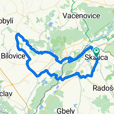
A cycling route starting in Skalica, Trnava Region, Slovakia.
Overview
About this route
The route starts in Skalica and leads to the Baťa Canal, from there to Adamov along the Morava river. From Adamov, you go on the main road to Gbely, Petrová Ves, Unín, and through Zámčisko to Viesky. From Viesky, the route leads to Radošovce. Koválovec through the vineyards and towards the lodge in the Skalické Mountains. From the lodge back to Skalica.
- -:--
- Duration
- 63.6 km
- Distance
- 516 m
- Ascent
- 516 m
- Descent
- ---
- Avg. speed
- ---
- Max. altitude
Continue with Bikemap
Use, edit, or download this cycling route
You would like to ride Cikiho trasa or customize it for your own trip? Here is what you can do with this Bikemap route:
Free features
- Save this route as favorite or in collections
- Copy & plan your own version of this route
- Sync your route with Garmin or Wahoo
Premium features
Free trial for 3 days, or one-time payment. More about Bikemap Premium.
- Navigate this route on iOS & Android
- Export a GPX / KML file of this route
- Create your custom printout (try it for free)
- Download this route for offline navigation
Discover more Premium features.
Get Bikemap PremiumFrom our community
Other popular routes starting in Skalica
 turisticka
- Distance
- 190.6 km
- Ascent
- 1,232 m
- Descent
- 1,221 m
- Location
- Skalica, Trnava Region, Slovakia
 Skalica - Kopčany
- Distance
- 18.3 km
- Ascent
- 43 m
- Descent
- 63 m
- Location
- Skalica, Trnava Region, Slovakia
 Skalica - Prietržka - Hrebeň - Trnovec - Holíč - Vrádište - Skalica
- Distance
- 26.4 km
- Ascent
- 159 m
- Descent
- 161 m
- Location
- Skalica, Trnava Region, Slovakia
 Skalica - Golfový klub - Skalické rybníky - Skalica
- Distance
- 9 km
- Ascent
- 38 m
- Descent
- 41 m
- Location
- Skalica, Trnava Region, Slovakia
 SKALICKE BUDY 2025
- Distance
- 74.2 km
- Ascent
- 491 m
- Descent
- 490 m
- Location
- Skalica, Trnava Region, Slovakia
 Skalica - Sudoměřice - Mlýnky
- Distance
- 11.1 km
- Ascent
- 136 m
- Descent
- 62 m
- Location
- Skalica, Trnava Region, Slovakia
 B08 Skalica - Cerova
- Distance
- 66.3 km
- Ascent
- 1,219 m
- Descent
- 1,169 m
- Location
- Skalica, Trnava Region, Slovakia
 Skalica-Holič-Kopčany-Mikulčice-Lužice-Hodonin
- Distance
- 48.8 km
- Ascent
- 184 m
- Descent
- 181 m
- Location
- Skalica, Trnava Region, Slovakia
Open it in the app