

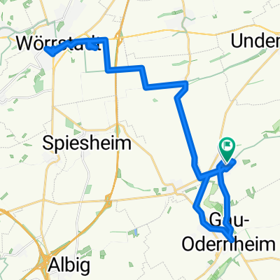
Undenheim - Bechtolsheim - Petersberg - Undenheim
A cycling route starting in Bechtolsheim, Rhineland-Palatinate, Germany.
Overview
About this route
Kleine Runde für Bergtraining, ausgehend aus Undenheim über Bechtolsheim auf´n Petersberg (gute Steigung), danach über die Felder Richtung Undenheim zurück und untem am Rewe rauskommend.
Wenn man nichts gegen Dreck hat, kann man auf dieser Tour bei jedem Wetter Spaß haben.... vor allem beim putzen später ;-)
- -:--
- Duration
- 18.2 km
- Distance
- 134 m
- Ascent
- 134 m
- Descent
- ---
- Avg. speed
- ---
- Max. altitude
Route quality
Waytypes & surfaces along the route
Waytypes
Track
11.8 km
(65 %)
Quiet road
4.8 km
(26 %)
Surfaces
Paved
11.5 km
(63 %)
Unpaved
4.5 km
(25 %)
Ground
4 km
(22 %)
Paved (undefined)
3.5 km
(19 %)
Continue with Bikemap
Use, edit, or download this cycling route
You would like to ride Undenheim - Bechtolsheim - Petersberg - Undenheim or customize it for your own trip? Here is what you can do with this Bikemap route:
Free features
- Save this route as favorite or in collections
- Copy & plan your own version of this route
- Sync your route with Garmin or Wahoo
Premium features
Free trial for 3 days, or one-time payment. More about Bikemap Premium.
- Navigate this route on iOS & Android
- Export a GPX / KML file of this route
- Create your custom printout (try it for free)
- Download this route for offline navigation
Discover more Premium features.
Get Bikemap PremiumFrom our community
Other popular routes starting in Bechtolsheim
 Ä„fÙ? nach Ä„fÙ?
- Distance
- 13.6 km
- Ascent
- 116 m
- Descent
- 65 m
- Location
- Bechtolsheim, Rhineland-Palatinate, Germany
 Vor dem Schloss 32, Bechtolsheim nach Friedrich-Ebert-Straße 2, Wörrstadt
- Distance
- 11.5 km
- Ascent
- 138 m
- Descent
- 55 m
- Location
- Bechtolsheim, Rhineland-Palatinate, Germany
 gassi
gassi- Distance
- 4.4 km
- Ascent
- 86 m
- Descent
- 132 m
- Location
- Bechtolsheim, Rhineland-Palatinate, Germany
 Bechtolsheim-Rüsselsheim
- Distance
- 32.4 km
- Ascent
- 112 m
- Descent
- 157 m
- Location
- Bechtolsheim, Rhineland-Palatinate, Germany
 Baumgartenstraße 18, Bechtolsheim nach Vorstadt 34, Kirchheimbolanden
- Distance
- 24.9 km
- Ascent
- 239 m
- Descent
- 127 m
- Location
- Bechtolsheim, Rhineland-Palatinate, Germany
 Hinter dem Schloß 26, Bechtolsheim nach Hinter dem Schloß 26, Bechtolsheim
- Distance
- 18.7 km
- Ascent
- 115 m
- Descent
- 116 m
- Location
- Bechtolsheim, Rhineland-Palatinate, Germany
 Rathausgasse nach Rathausgasse
- Distance
- 41 km
- Ascent
- 680 m
- Descent
- 683 m
- Location
- Bechtolsheim, Rhineland-Palatinate, Germany
 gassi mittel
- Distance
- 4.2 km
- Ascent
- 32 m
- Descent
- 81 m
- Location
- Bechtolsheim, Rhineland-Palatinate, Germany
Open it in the app