

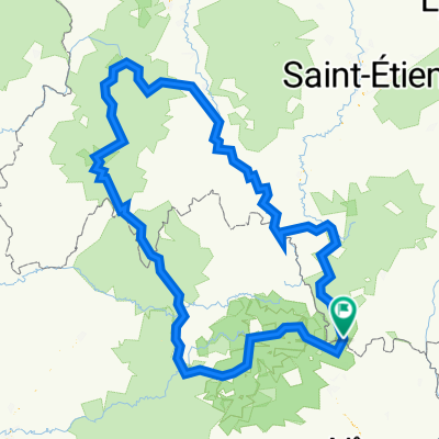
D-130201 - Etoile de Bessèges - Etape 03
A cycling route starting in Bessèges, Occitanie, France.
Overview
About this route
Race: Etoile de BessègesStage: 03Category: UCI Europe Tour
Class: 2.1Date: 1 February 2013Start: Bessèges (France)End: Bessèges (France)Distance: 152.6 Km
- -:--
- Duration
- 153.7 km
- Distance
- 1,312 m
- Ascent
- 1,314 m
- Descent
- ---
- Avg. speed
- ---
- Max. altitude
Route quality
Waytypes & surfaces along the route
Waytypes
Road
93.7 km
(61 %)
Quiet road
9.2 km
(6 %)
Surfaces
Paved
76.8 km
(50 %)
Unpaved
1.5 km
(1 %)
Asphalt
76.8 km
(50 %)
Unpaved (undefined)
1.5 km
(1 %)
Undefined
75.3 km
(49 %)
Continue with Bikemap
Use, edit, or download this cycling route
You would like to ride D-130201 - Etoile de Bessèges - Etape 03 or customize it for your own trip? Here is what you can do with this Bikemap route:
Free features
- Save this route as favorite or in collections
- Copy & plan your own version of this route
- Split it into stages to create a multi-day tour
- Sync your route with Garmin or Wahoo
Premium features
Free trial for 3 days, or one-time payment. More about Bikemap Premium.
- Navigate this route on iOS & Android
- Export a GPX / KML file of this route
- Create your custom printout (try it for free)
- Download this route for offline navigation
Discover more Premium features.
Get Bikemap PremiumFrom our community
Other popular routes starting in Bessèges
 COl du pre de la dame
- Distance
- 82 km
- Ascent
- 1,885 m
- Descent
- 1,885 m
- Location
- Bessèges, Occitanie, France
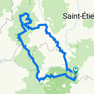
 Stage 3 - Étoile de Bessèges 2014 - Bessèges-Bessèges
- Distance
- 149.5 km
- Ascent
- 1,345 m
- Descent
- 1,343 m
- Location
- Bessèges, Occitanie, France
 GTMC V2
- Distance
- 709.9 km
- Ascent
- 16,787 m
- Descent
- 16,785 m
- Location
- Bessèges, Occitanie, France
 De Impasse du Tunnel 150, Saint-Paul-le-Jeune à Le Fort 1, Banne
- Distance
- 728.3 km
- Ascent
- 23,471 m
- Descent
- 23,456 m
- Location
- Bessèges, Occitanie, France
 D-130201 - Etoile de Bessèges - Etape 03
- Distance
- 153.7 km
- Ascent
- 1,312 m
- Descent
- 1,314 m
- Location
- Bessèges, Occitanie, France
 Ceze Rundfahrt
- Distance
- 56.6 km
- Ascent
- 752 m
- Descent
- 755 m
- Location
- Bessèges, Occitanie, France
 Cevennes - Rund um die Céze
- Distance
- 63.5 km
- Ascent
- 889 m
- Descent
- 889 m
- Location
- Bessèges, Occitanie, France
 GTMC Final P1
- Distance
- 335.4 km
- Ascent
- 8,651 m
- Descent
- 8,276 m
- Location
- Bessèges, Occitanie, France
Open it in the app