

Triathlon des Gorges de l'Ardèche
A cycling route starting in Saint-Julien-de-Peyrolas, Occitanie, France.
Overview
About this route
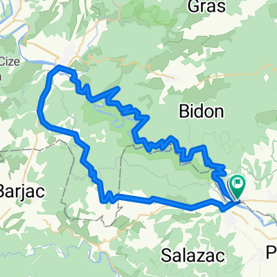
Cycling route of the Triathlon des Gorges de l'Ardèche.
- -:--
- Duration
- 38.6 km
- Distance
- 570 m
- Ascent
- 525 m
- Descent
- ---
- Avg. speed
- ---
- Max. altitude
Route quality
Waytypes & surfaces along the route
Waytypes
Quiet road
1.2 km
(3 %)
Road
0.8 km
(2 %)
Surfaces
Paved
38.2 km
(99 %)
Asphalt
38.2 km
(99 %)
Undefined
0.4 km
(1 %)
Continue with Bikemap
Use, edit, or download this cycling route
You would like to ride Triathlon des Gorges de l'Ardèche or customize it for your own trip? Here is what you can do with this Bikemap route:
Free features
- Save this route as favorite or in collections
- Copy & plan your own version of this route
- Sync your route with Garmin or Wahoo
Premium features
Free trial for 3 days, or one-time payment. More about Bikemap Premium.
- Navigate this route on iOS & Android
- Export a GPX / KML file of this route
- Create your custom printout (try it for free)
- Download this route for offline navigation
Discover more Premium features.
Get Bikemap PremiumFrom our community
Other popular routes starting in Saint-Julien-de-Peyrolas
 Triathlon des Gorges de l'Ardèche distance L Natation
- Distance
- 2 km
- Ascent
- 112 m
- Descent
- 111 m
- Location
- Saint-Julien-de-Peyrolas, Occitanie, France
 TGA2018d - Parcours CàP dist. L
- Distance
- 19.9 km
- Ascent
- 175 m
- Descent
- 172 m
- Location
- Saint-Julien-de-Peyrolas, Occitanie, France
 Roche guide
- Distance
- 69 km
- Ascent
- 346 m
- Descent
- 345 m
- Location
- Saint-Julien-de-Peyrolas, Occitanie, France
 12. Tag Camping des Grottes - Montelimar
- Distance
- 88.2 km
- Ascent
- 611 m
- Descent
- 758 m
- Location
- Saint-Julien-de-Peyrolas, Occitanie, France
 Ardeche
- Distance
- 68.2 km
- Ascent
- 819 m
- Descent
- 807 m
- Location
- Saint-Julien-de-Peyrolas, Occitanie, France
 St-Julien to Mas De Serret
- Distance
- 26.4 km
- Ascent
- 333 m
- Descent
- 218 m
- Location
- Saint-Julien-de-Peyrolas, Occitanie, France
 Long bike tour through Laval-St.-Roman
- Distance
- 77.3 km
- Ascent
- 733 m
- Descent
- 733 m
- Location
- Saint-Julien-de-Peyrolas, Occitanie, France
 St-Julien Salazac Chartreuse Valbonne
- Distance
- 28 km
- Ascent
- 439 m
- Descent
- 439 m
- Location
- Saint-Julien-de-Peyrolas, Occitanie, France
Open it in the app