

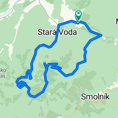
Švedlar Genier Stara Voda strará štôlna Švedlar
A cycling route starting in Krompachy, Košice Region, Slovakia.
Overview
About this route
The more information you write here, the more useful it will be for other users.* Route details.* What is special about this route?* Why recommend this route?* What did you like most here?* Etc.
- -:--
- Duration
- 30.2 km
- Distance
- 828 m
- Ascent
- 766 m
- Descent
- ---
- Avg. speed
- 934 m
- Max. altitude

Route quality
Waytypes & surfaces along the route
Waytypes
Track
22.4 km
(74 %)
Quiet road
2.1 km
(7 %)
Surfaces
Paved
4.2 km
(14 %)
Unpaved
18.4 km
(61 %)
Unpaved (undefined)
8.2 km
(27 %)
Gravel
5.7 km
(19 %)
Route highlights
Points of interest along the route
Point of interest after 30.2 km
KONECNA BEER STOP
Continue with Bikemap
Use, edit, or download this cycling route
You would like to ride Švedlar Genier Stara Voda strará štôlna Švedlar or customize it for your own trip? Here is what you can do with this Bikemap route:
Free features
- Save this route as favorite or in collections
- Copy & plan your own version of this route
- Sync your route with Garmin or Wahoo
Premium features
Free trial for 3 days, or one-time payment. More about Bikemap Premium.
- Navigate this route on iOS & Android
- Export a GPX / KML file of this route
- Create your custom printout (try it for free)
- Download this route for offline navigation
Discover more Premium features.
Get Bikemap PremiumFrom our community
Other popular routes starting in Krompachy
 1deň Ostrý kameň 2deň Genier......túra
- Distance
- 16.3 km
- Ascent
- 1,029 m
- Descent
- 1,029 m
- Location
- Krompachy, Košice Region, Slovakia
 Plejsy priehyba-Žakarovce-Mária Huta
- Distance
- 7 km
- Ascent
- 62 m
- Descent
- 606 m
- Location
- Krompachy, Košice Region, Slovakia
 2016_Wien_Lwiw_Tag03_202km_2.500hm
- Distance
- 201.4 km
- Ascent
- 1,439 m
- Descent
- 1,370 m
- Location
- Krompachy, Košice Region, Slovakia
 Krompachy - Kosice
- Distance
- 48.6 km
- Ascent
- 547 m
- Descent
- 720 m
- Location
- Krompachy, Košice Region, Slovakia
 Švedlár Závadka up and down 40 km
- Distance
- 39.7 km
- Ascent
- 1,327 m
- Descent
- 1,164 m
- Location
- Krompachy, Košice Region, Slovakia
 Švedlar-Skalisko Zlatý stôl -tunel- Švedlar
- Distance
- 49.5 km
- Ascent
- 1,146 m
- Descent
- 1,143 m
- Location
- Krompachy, Košice Region, Slovakia
 Švedlár Zlatý stôl kanal Švedlár
- Distance
- 46.9 km
- Ascent
- 1,049 m
- Descent
- 1,051 m
- Location
- Krompachy, Košice Region, Slovakia
 Spišských 333EXTREME
- Distance
- 329.5 km
- Ascent
- 3,653 m
- Descent
- 3,653 m
- Location
- Krompachy, Košice Region, Slovakia
Open it in the app