

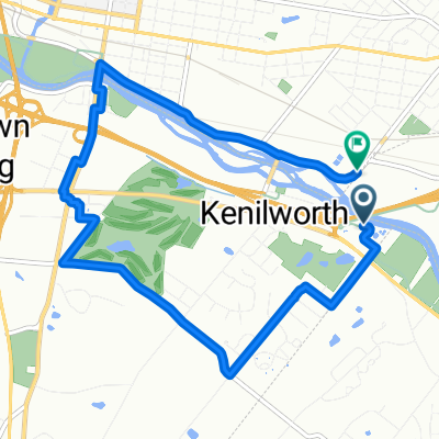
Commute from French Creek to GSK
A cycling route starting in Kenilworth, Pennsylvania, United States.
Overview
About this route
Commuting route to try to avoid traffic to work.
- -:--
- Duration
- 23.1 km
- Distance
- 150 m
- Ascent
- 192 m
- Descent
- ---
- Avg. speed
- 141 m
- Max. altitude
Route quality
Waytypes & surfaces along the route
Waytypes
Road
9.3 km
(40 %)
Busy road
5.8 km
(25 %)
Surfaces
Paved
12.2 km
(53 %)
Asphalt
12.2 km
(53 %)
Undefined
10.9 km
(47 %)
Continue with Bikemap
Use, edit, or download this cycling route
You would like to ride Commute from French Creek to GSK or customize it for your own trip? Here is what you can do with this Bikemap route:
Free features
- Save this route as favorite or in collections
- Copy & plan your own version of this route
- Sync your route with Garmin or Wahoo
Premium features
Free trial for 3 days, or one-time payment. More about Bikemap Premium.
- Navigate this route on iOS & Android
- Export a GPX / KML file of this route
- Create your custom printout (try it for free)
- Download this route for offline navigation
Discover more Premium features.
Get Bikemap PremiumFrom our community
Other popular routes starting in Kenilworth
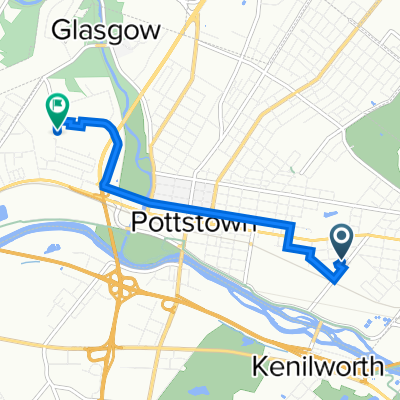
 Route in Pottstown
- Distance
- 8.9 km
- Ascent
- 67 m
- Descent
- 71 m
- Location
- Kenilworth, Pennsylvania, United States
 South Street 892, Pottstown to Shoemaker Road 233, Pottstown
- Distance
- 4.7 km
- Ascent
- 44 m
- Descent
- 39 m
- Location
- Kenilworth, Pennsylvania, United States
 91 Wil-Be Dr, Pottstown to 1495 E High St, Pottstown
- Distance
- 9.3 km
- Ascent
- 68 m
- Descent
- 71 m
- Location
- Kenilworth, Pennsylvania, United States
 1601 New Schuylkill Rd, Pottstown to 1601 New Schuylkill Rd, Pottstown
- Distance
- 33.1 km
- Ascent
- 171 m
- Descent
- 171 m
- Location
- Kenilworth, Pennsylvania, United States
 Commute from French Creek to GSK
- Distance
- 23.1 km
- Ascent
- 150 m
- Descent
- 192 m
- Location
- Kenilworth, Pennsylvania, United States
 Slow ride in Pottstown
- Distance
- 32.5 km
- Ascent
- 167 m
- Descent
- 167 m
- Location
- Kenilworth, Pennsylvania, United States
 1004 Beech St, Pottstown to Rolling Hills Dr, Pottstown
- Distance
- 4.1 km
- Ascent
- 36 m
- Descent
- 30 m
- Location
- Kenilworth, Pennsylvania, United States
 Rt 23 out and back 20.1 mile
- Distance
- 16.1 km
- Ascent
- 266 m
- Descent
- 174 m
- Location
- Kenilworth, Pennsylvania, United States
Open it in the app