

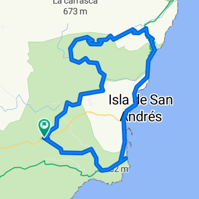
Venta del Pobre-Nijar-Lucainena-Turrilla-Colativid-Sorbas-Venta
A cycling route starting in Los Alamillos, Andalusia, Spain.
Overview
About this route
You leave Venta Del Pobre via the secondary road to Campohermoso. You start climbing, passing through Nijar towards Lucainena, crossing the Lucainena pass until you reach the village. At the exit, you take the turn to go to Turrilla; from there you continue climbing to reach the highest point of the Sierra Alhamilla, the Colativid. The return is made descending to the national road of Tabernas, then heading towards Sorbas. After passing Sorbas, you take the turn that goes to Venta Del Pobre via the so-called Rio de Agua road.
- -:--
- Duration
- 112.1 km
- Distance
- 1,530 m
- Ascent
- 1,528 m
- Descent
- ---
- Avg. speed
- ---
- Max. altitude

Route quality
Waytypes & surfaces along the route
Waytypes
Road
62.8 km
(56 %)
Quiet road
24.7 km
(22 %)
Surfaces
Paved
20.2 km
(18 %)
Unpaved
4.5 km
(4 %)
Asphalt
16.8 km
(15 %)
Gravel
4.5 km
(4 %)
Continue with Bikemap
Use, edit, or download this cycling route
You would like to ride Venta del Pobre-Nijar-Lucainena-Turrilla-Colativid-Sorbas-Venta or customize it for your own trip? Here is what you can do with this Bikemap route:
Free features
- Save this route as favorite or in collections
- Copy & plan your own version of this route
- Split it into stages to create a multi-day tour
- Sync your route with Garmin or Wahoo
Premium features
Free trial for 3 days, or one-time payment. More about Bikemap Premium.
- Navigate this route on iOS & Android
- Export a GPX / KML file of this route
- Create your custom printout (try it for free)
- Download this route for offline navigation
Discover more Premium features.
Get Bikemap PremiumFrom our community
Other popular routes starting in Los Alamillos
 De Calle La Tortola 16-20, Fernán Pérez a Paraje Los Escullos s/n
- Distance
- 41.9 km
- Ascent
- 353 m
- Descent
- 571 m
- Location
- Los Alamillos, Andalusia, Spain
 AGUA AMARGA COLATIVI
- Distance
- 77.2 km
- Ascent
- 1,225 m
- Descent
- 1,398 m
- Location
- Los Alamillos, Andalusia, Spain
 Ln-Rodalq-Minas-Cortijo-Ln
- Distance
- 20.6 km
- Ascent
- 442 m
- Descent
- 450 m
- Location
- Los Alamillos, Andalusia, Spain
 Carboneras, ramblas y alrededores
- Distance
- 52.3 km
- Ascent
- 894 m
- Descent
- 894 m
- Location
- Los Alamillos, Andalusia, Spain
 AGUA AMARGA COLATIVI
- Distance
- 77.3 km
- Ascent
- 1,225 m
- Descent
- 1,398 m
- Location
- Los Alamillos, Andalusia, Spain
 gafares albericoques
- Distance
- 32.5 km
- Ascent
- 251 m
- Descent
- 305 m
- Location
- Los Alamillos, Andalusia, Spain
 Loop Las Negras Agua Amarga
- Distance
- 28.8 km
- Ascent
- 749 m
- Descent
- 749 m
- Location
- Los Alamillos, Andalusia, Spain
 Venta del Pobre-Nijar-Lucainena-Turrilla-Colativid-Sorbas-Venta
- Distance
- 112.1 km
- Ascent
- 1,530 m
- Descent
- 1,528 m
- Location
- Los Alamillos, Andalusia, Spain
Open it in the app