
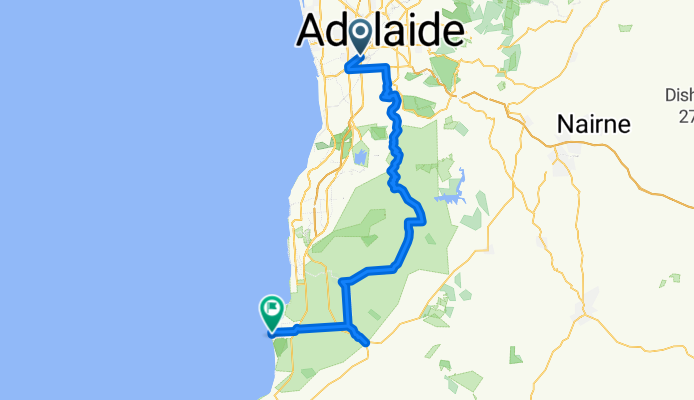
Bike Society Tour + Lunch Event
A cycling route starting in Forestville, South Australia, Australia.
Overview
About this route
Bike Society Under the Tour Ride Details.
- -:--
- Duration
- 77.1 km
- Distance
- 894 m
- Ascent
- 910 m
- Descent
- ---
- Avg. speed
- ---
- Max. altitude
Route quality
Waytypes & surfaces along the route
Waytypes
Busy road
60.1 km
(78 %)
Cycleway
7.4 km
(10 %)
Surfaces
Paved
73.8 km
(96 %)
Unpaved
0.1 km
(<1 %)
Asphalt
62.9 km
(82 %)
Paved (undefined)
10.9 km
(14 %)
Route highlights
Points of interest along the route
Point of interest after 65.8 km
Van will stop with Option to ride up Willunga hill and back down.
Continue with Bikemap
Use, edit, or download this cycling route
You would like to ride Bike Society Tour + Lunch Event or customize it for your own trip? Here is what you can do with this Bikemap route:
Free features
- Save this route as favorite or in collections
- Copy & plan your own version of this route
- Sync your route with Garmin or Wahoo
Premium features
Free trial for 3 days, or one-time payment. More about Bikemap Premium.
- Navigate this route on iOS & Android
- Export a GPX / KML file of this route
- Create your custom printout (try it for free)
- Download this route for offline navigation
Discover more Premium features.
Get Bikemap PremiumFrom our community
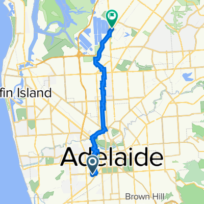
Other popular routes starting in Forestville
 circle Adelside
- Distance
- 28.8 km
- Ascent
- 147 m
- Descent
- 144 m
- Location
- Forestville, South Australia, Australia
 Bike Society Tour + Lunch Event
- Distance
- 77.1 km
- Ascent
- 894 m
- Descent
- 910 m
- Location
- Forestville, South Australia, Australia
 Keswick to Dry Creek Wetlands via Kilburn.
- Distance
- 20.3 km
- Ascent
- 85 m
- Descent
- 111 m
- Location
- Forestville, South Australia, Australia
 Keswick to Dry Creek Wetlands via 4WD SupaStore
- Distance
- 20.3 km
- Ascent
- 80 m
- Descent
- 106 m
- Location
- Forestville, South Australia, Australia
 Hills Ride
- Distance
- 58.8 km
- Ascent
- 654 m
- Descent
- 654 m
- Location
- Forestville, South Australia, Australia
 Westside Bikeway (Anaconda to Glenelg)
- Distance
- 8.9 km
- Ascent
- 0 m
- Descent
- 9 m
- Location
- Forestville, South Australia, Australia
 city to glenglg
- Distance
- 6.6 km
- Ascent
- 24 m
- Descent
- 42 m
- Location
- Forestville, South Australia, Australia
 Richmond Road Netley to First Ave Forestville
- Distance
- 6.6 km
- Ascent
- 265 m
- Descent
- 256 m
- Location
- Forestville, South Australia, Australia
Open it in the app