Rhönrunde mit Weitblick 2
A cycling route starting in Schleid, Thuringia, Germany.
Overview
About this route
Start der Tour ist im thüringischen Teil der Rhoen, in Motzlar. Nach Überqueren der hessischen Landesgrenze verläuft die Route über Schwarzbach, Eckweisbach, an der Wasserkuppe vorbei Richtung Bischofsheim zum Kreuzberg.
Der Rückweg verläuft auf der Hochrhoenstraße Richtung Frankenheim, durch Tann, entlang der Ulster wieder nach Motzlar.
- -:--
- Duration
- 107.7 km
- Distance
- 1,679 m
- Ascent
- 1,679 m
- Descent
- ---
- Avg. speed
- ---
- Max. altitude
Route quality
Waytypes & surfaces along the route
Waytypes
Busy road
60.8 km
(56 %)
Road
42.7 km
(40 %)
Surfaces
Paved
82.2 km
(76 %)
Unpaved
0.4 km
(<1 %)
Asphalt
81.3 km
(76 %)
Paved (undefined)
0.9 km
(<1 %)
Continue with Bikemap
Use, edit, or download this cycling route
You would like to ride Rhönrunde mit Weitblick 2 or customize it for your own trip? Here is what you can do with this Bikemap route:
Free features
- Save this route as favorite or in collections
- Copy & plan your own version of this route
- Split it into stages to create a multi-day tour
- Sync your route with Garmin or Wahoo
Premium features
Free trial for 3 days, or one-time payment. More about Bikemap Premium.
- Navigate this route on iOS & Android
- Export a GPX / KML file of this route
- Create your custom printout (try it for free)
- Download this route for offline navigation
Discover more Premium features.
Get Bikemap PremiumFrom our community
Other popular routes starting in Schleid
- Rhönrunde mit Weitblick 1
- Distance
- 128.7 km
- Ascent
- 1,291 m
- Descent
- 1,291 m
- Location
- Schleid, Thuringia, Germany
- Schleid Cycling
- Distance
- 92 km
- Ascent
- 394 m
- Descent
- 522 m
- Location
- Schleid, Thuringia, Germany
- Rhönrunde mit Weitblick 2
- Distance
- 107.7 km
- Ascent
- 1,679 m
- Descent
- 1,679 m
- Location
- Schleid, Thuringia, Germany
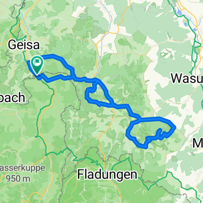
- Druch die thueringische Rhoen
- Distance
- 116.5 km
- Ascent
- 1,670 m
- Descent
- 1,670 m
- Location
- Schleid, Thuringia, Germany
- Ketten Boxberg
- Distance
- 16.9 km
- Ascent
- 443 m
- Descent
- 443 m
- Location
- Schleid, Thuringia, Germany
- Tann-Frankenheim-Fladungen-Hohe Geba-Kaltennordheim
- Distance
- 90.4 km
- Ascent
- 1,453 m
- Descent
- 1,453 m
- Location
- Schleid, Thuringia, Germany
- schleid-felda-werra-ulster
- Distance
- 64.5 km
- Ascent
- 425 m
- Descent
- 427 m
- Location
- Schleid, Thuringia, Germany
- Motzlar - Kuhberg - Habelberg - Motzlar
- Distance
- 34 km
- Ascent
- 537 m
- Descent
- 537 m
- Location
- Schleid, Thuringia, Germany
Open it in the app