

Feierabend
A cycling route starting in Alt-Treptow, State of Berlin, Germany.
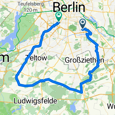
Overview
About this route
straight from work... somehow around the BBI... should fit somewhat in the south...
- -:--
- Duration
- 66.1 km
- Distance
- 64 m
- Ascent
- 67 m
- Descent
- ---
- Avg. speed
- 55 m
- Max. altitude

Route quality
Waytypes & surfaces along the route
Waytypes
Path
23.1 km
(35 %)
Road
15.2 km
(23 %)
Surfaces
Paved
54.2 km
(82 %)
Unpaved
4.6 km
(7 %)
Asphalt
54.2 km
(82 %)
Gravel
2 km
(3 %)
Continue with Bikemap
Use, edit, or download this cycling route
You would like to ride Feierabend or customize it for your own trip? Here is what you can do with this Bikemap route:
Free features
- Save this route as favorite or in collections
- Copy & plan your own version of this route
- Sync your route with Garmin or Wahoo
Premium features
Free trial for 3 days, or one-time payment. More about Bikemap Premium.
- Navigate this route on iOS & Android
- Export a GPX / KML file of this route
- Create your custom printout (try it for free)
- Download this route for offline navigation
Discover more Premium features.
Get Bikemap PremiumFrom our community
Other popular routes starting in Alt-Treptow
 Slow Evening Course In Berlin
- Distance
- 12 km
- Ascent
- 552 m
- Descent
- 562 m
- Location
- Alt-Treptow, State of Berlin, Germany
 Berlin-Treptow - Klein Wall
- Distance
- 85.6 km
- Ascent
- 182 m
- Descent
- 182 m
- Location
- Alt-Treptow, State of Berlin, Germany
 Fahren & Fressen: Yogihaus
- Distance
- 64.9 km
- Ascent
- 85 m
- Descent
- 79 m
- Location
- Alt-Treptow, State of Berlin, Germany
 Rund-um-den-BBI-Rennradrunde
- Distance
- 89.8 km
- Ascent
- 124 m
- Descent
- 123 m
- Location
- Alt-Treptow, State of Berlin, Germany
 2-Täler-Tour
- Distance
- 65.5 km
- Ascent
- 77 m
- Descent
- 77 m
- Location
- Alt-Treptow, State of Berlin, Germany
 Treptow-SXF-Mittenwalde-Bestensee-Storkow-Kolberg-Friedersdorf-KW-Grünau-Treptow
- Distance
- 126.1 km
- Ascent
- 229 m
- Descent
- 226 m
- Location
- Alt-Treptow, State of Berlin, Germany
 Treptow-SXF-Mittenwalde-Gr. Machnow-KW-Grünau-Treptow
- Distance
- 88.8 km
- Ascent
- 135 m
- Descent
- 133 m
- Location
- Alt-Treptow, State of Berlin, Germany
 Erkundungstour Rangsdorf
- Distance
- 114.5 km
- Ascent
- 114 m
- Descent
- 111 m
- Location
- Alt-Treptow, State of Berlin, Germany
Open it in the app