

2. TEIL AT13: Bieberwier - Imsterberg
A cycling route starting in Biberwier, Tyrol, Austria.
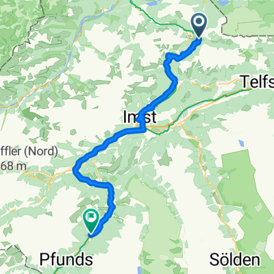
Overview
About this route
- -:--
- Duration
- 37.2 km
- Distance
- 590 m
- Ascent
- 671 m
- Descent
- ---
- Avg. speed
- ---
- Max. altitude
Route quality
Waytypes & surfaces along the route
Waytypes
Track
24.6 km
(66 %)
Quiet road
4.8 km
(13 %)
Surfaces
Paved
11.2 km
(30 %)
Unpaved
22.7 km
(61 %)
Gravel
17.9 km
(48 %)
Asphalt
11.2 km
(30 %)
Continue with Bikemap
Use, edit, or download this cycling route
You would like to ride 2. TEIL AT13: Bieberwier - Imsterberg or customize it for your own trip? Here is what you can do with this Bikemap route:
Free features
- Save this route as favorite or in collections
- Copy & plan your own version of this route
- Sync your route with Garmin or Wahoo
Premium features
Free trial for 3 days, or one-time payment. More about Bikemap Premium.
- Navigate this route on iOS & Android
- Export a GPX / KML file of this route
- Create your custom printout (try it for free)
- Download this route for offline navigation
Discover more Premium features.
Get Bikemap PremiumFrom our community
Other popular routes starting in Biberwier
 8. Etappe: Biberwier - Zams
- Distance
- 59.3 km
- Ascent
- 1,220 m
- Descent
- 1,452 m
- Location
- Biberwier, Tyrol, Austria
 z-B31EHR-Biberwier-3 Seen Runde
- Distance
- 11.2 km
- Ascent
- 357 m
- Descent
- 357 m
- Location
- Biberwier, Tyrol, Austria
 L71 64, Biberwier nach Malserstraße 31, Landeck
- Distance
- 54.4 km
- Ascent
- 651 m
- Descent
- 852 m
- Location
- Biberwier, Tyrol, Austria
 MTB Fernpass - Megatrails
- Distance
- 82 km
- Ascent
- 3,542 m
- Descent
- 3,543 m
- Location
- Biberwier, Tyrol, Austria
 Gipfeltour Sonnenspitze
- Distance
- 4 km
- Ascent
- 606 m
- Descent
- 614 m
- Location
- Biberwier, Tyrol, Austria
 Alpencross 1.Etappe
- Distance
- 72.6 km
- Ascent
- 1,242 m
- Descent
- 795 m
- Location
- Biberwier, Tyrol, Austria
 Biberwier - Serfaus
- Distance
- 76.6 km
- Ascent
- 1,703 m
- Descent
- 1,739 m
- Location
- Biberwier, Tyrol, Austria
 Ö5Biberw-Garmisch-Ahornbogen (Eng)
- Distance
- 89.6 km
- Ascent
- 1,082 m
- Descent
- 875 m
- Location
- Biberwier, Tyrol, Austria
Open it in the app