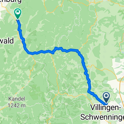
Schwenninger Kurs
A cycling route starting in Dauchingen, Baden-Württemberg, Germany.
Overview
About this route
Masters-Meisterschaftskurs 2008 und 2009
- -:--
- Duration
- 6.4 km
- Distance
- 69 m
- Ascent
- 68 m
- Descent
- ---
- Avg. speed
- 771 m
- Avg. speed
Route quality
Waytypes & surfaces along the route
Waytypes
Road
3.5 km
(54 %)
Quiet road
1.3 km
(20 %)
Surfaces
Paved
4.7 km
(73 %)
Asphalt
4.7 km
(73 %)
Undefined
1.8 km
(27 %)
Continue with Bikemap
Use, edit, or download this cycling route
You would like to ride Schwenninger Kurs or customize it for your own trip? Here is what you can do with this Bikemap route:
Free features
- Save this route as favorite or in collections
- Copy & plan your own version of this route
- Sync your route with Garmin or Wahoo
Premium features
Free trial for 3 days, or one-time payment. More about Bikemap Premium.
- Navigate this route on iOS & Android
- Export a GPX / KML file of this route
- Create your custom printout (try it for free)
- Download this route for offline navigation
Discover more Premium features.
Get Bikemap PremiumFrom our community
Other popular routes starting in Dauchingen
- Thyssen Testturm - Rottwei
- Distance
- 48.4 km
- Ascent
- 1,084 m
- Descent
- 1,083 m
- Location
- Dauchingen, Baden-Württemberg, Germany
- Weilersbach über Burgberg nach Gengenbach
- Distance
- 73.8 km
- Ascent
- 1,178 m
- Descent
- 1,729 m
- Location
- Dauchingen, Baden-Württemberg, Germany
- Eschachtal-Runde
- Distance
- 33 km
- Ascent
- 383 m
- Descent
- 383 m
- Location
- Dauchingen, Baden-Württemberg, Germany
- Neckartal Radweg
- Distance
- 358.1 km
- Ascent
- 3,047 m
- Descent
- 3,633 m
- Location
- Dauchingen, Baden-Württemberg, Germany
- Weilersbach über Tischneck nach Schramberg Schiltach Hausach
- Distance
- 48.4 km
- Ascent
- 1,297 m
- Descent
- 1,766 m
- Location
- Dauchingen, Baden-Württemberg, Germany
- Corona Homerun
- Distance
- 61.6 km
- Ascent
- 559 m
- Descent
- 562 m
- Location
- Dauchingen, Baden-Württemberg, Germany
- Weilersbach, Schwenningen, Deißlingen
- Distance
- 28.8 km
- Ascent
- 353 m
- Descent
- 353 m
- Location
- Dauchingen, Baden-Württemberg, Germany
- Oberhohenberg - Schörzinger Hütte
- Distance
- 54.2 km
- Ascent
- 633 m
- Descent
- 641 m
- Location
- Dauchingen, Baden-Württemberg, Germany
Open it in the app