

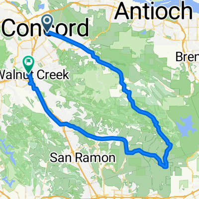
Concord BART to Walnut Creek BART via Morgan Territory
A cycling route starting in Concord, California, United States.
Overview
About this route
Cocord BART to Walnut Creek BART via Morgan Territory Rd.
- -:--
- Duration
- 78.2 km
- Distance
- 791 m
- Ascent
- 777 m
- Descent
- ---
- Avg. speed
- ---
- Max. altitude

Route quality
Waytypes & surfaces along the route
Waytypes
Road
43 km
(55 %)
Quiet road
10.9 km
(14 %)
Surfaces
Paved
3.1 km
(4 %)
Asphalt
2.3 km
(3 %)
Paved (undefined)
0.8 km
(1 %)
Undefined
75.1 km
(96 %)
Continue with Bikemap
Use, edit, or download this cycling route
You would like to ride Concord BART to Walnut Creek BART via Morgan Territory or customize it for your own trip? Here is what you can do with this Bikemap route:
Free features
- Save this route as favorite or in collections
- Copy & plan your own version of this route
- Sync your route with Garmin or Wahoo
Premium features
Free trial for 3 days, or one-time payment. More about Bikemap Premium.
- Navigate this route on iOS & Android
- Export a GPX / KML file of this route
- Create your custom printout (try it for free)
- Download this route for offline navigation
Discover more Premium features.
Get Bikemap PremiumFrom our community
Other popular routes starting in Concord
 Concord BART to Walnut Creek BART via Morgan Territory
- Distance
- 78.2 km
- Ascent
- 791 m
- Descent
- 777 m
- Location
- Concord, California, United States
 OYJ Morgan Territory (HIA)
- Distance
- 77.4 km
- Ascent
- 1,011 m
- Descent
- 957 m
- Location
- Concord, California, United States
 Maria Court 3219, Concord to Detroit Avenue 1741, Concord
- Distance
- 15.5 km
- Ascent
- 56 m
- Descent
- 75 m
- Location
- Concord, California, United States
 Morgan Territory, Mount Diablo, and the last of 3 Bears.
- Distance
- 149.7 km
- Ascent
- 2,258 m
- Descent
- 2,283 m
- Location
- Concord, California, United States
 concord to lake berryessa
- Distance
- 83.7 km
- Ascent
- 111 m
- Descent
- 267 m
- Location
- Concord, California, United States
 Concord Bart to Walnut Creek Bart via Alhambra Rd.
- Distance
- 44.9 km
- Ascent
- 560 m
- Descent
- 537 m
- Location
- Concord, California, United States
 Detroit Avenue 1741, Concord to Detroit Avenue 1741, Concord
- Distance
- 17.2 km
- Ascent
- 98 m
- Descent
- 99 m
- Location
- Concord, California, United States
 1896 Lynwood Dr, Concord to 1896 Lynwood Dr, Concord
- Distance
- 10.6 km
- Ascent
- 22 m
- Descent
- 23 m
- Location
- Concord, California, United States
Open it in the app