

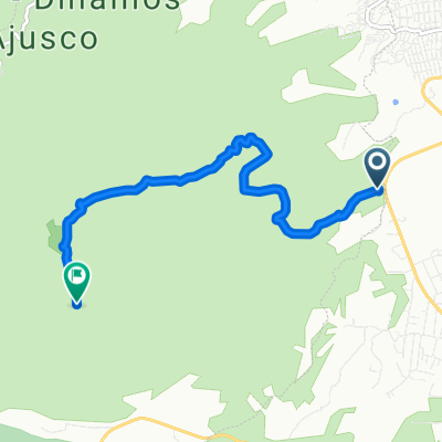
CIRCUITO AJUSCO
A cycling route starting in Lomas de Tepemecatl, Mexico City, Mexico.
Overview
About this route
- -:--
- Duration
- 26.2 km
- Distance
- 530 m
- Ascent
- 567 m
- Descent
- ---
- Avg. speed
- ---
- Max. altitude

Route quality
Waytypes & surfaces along the route
Waytypes
Quiet road
4.7 km
(18 %)
Track
0.5 km
(2 %)
Undefined
20.9 km
(80 %)
Continue with Bikemap
Use, edit, or download this cycling route
You would like to ride CIRCUITO AJUSCO or customize it for your own trip? Here is what you can do with this Bikemap route:
Free features
- Save this route as favorite or in collections
- Copy & plan your own version of this route
- Sync your route with Garmin or Wahoo
Premium features
Free trial for 3 days, or one-time payment. More about Bikemap Premium.
- Navigate this route on iOS & Android
- Export a GPX / KML file of this route
- Create your custom printout (try it for free)
- Download this route for offline navigation
Discover more Premium features.
Get Bikemap PremiumFrom our community
Other popular routes starting in Lomas de Tepemecatl
 Ruta moderada en
- Distance
- 7 km
- Ascent
- 235 m
- Descent
- 270 m
- Location
- Lomas de Tepemecatl, Mexico City, Mexico
 Ajusco - Las Llantas
- Distance
- 7.1 km
- Ascent
- 578 m
- Descent
- 79 m
- Location
- Lomas de Tepemecatl, Mexico City, Mexico
 Ajusco ruta zero
- Distance
- 16 km
- Ascent
- 389 m
- Descent
- 414 m
- Location
- Lomas de Tepemecatl, Mexico City, Mexico
 Ciclopista Ferrocarril de Cuernavaca, Tlalpan a Carretera México-Ajusco, Tlalpan
- Distance
- 9.9 km
- Ascent
- 178 m
- Descent
- 218 m
- Location
- Lomas de Tepemecatl, Mexico City, Mexico
 Paseo fácil
- Distance
- 17.3 km
- Ascent
- 595 m
- Descent
- 568 m
- Location
- Lomas de Tepemecatl, Mexico City, Mexico
 CIRCUITO AJUSCO
- Distance
- 26.2 km
- Ascent
- 530 m
- Descent
- 567 m
- Location
- Lomas de Tepemecatl, Mexico City, Mexico
 V.Tezontle - Capulin F.del Toro - Topilejo V. Tezontle 14 de Agosto 2016
- Distance
- 64.9 km
- Ascent
- 1,140 m
- Descent
- 1,140 m
- Location
- Lomas de Tepemecatl, Mexico City, Mexico
 VALLE DE LA CANTIMPLORA regreso SME
- Distance
- 51 km
- Ascent
- 145 m
- Descent
- 1,523 m
- Location
- Lomas de Tepemecatl, Mexico City, Mexico
Open it in the app