

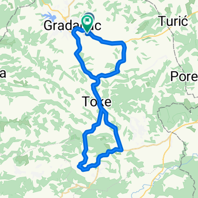
Gradacac-Biberovo polje
A cycling route starting in Gradačac, Federation of Bosnia and Herzegovina, Bosnia and Herzegovina.
Overview
About this route
- -:--
- Duration
- 33.7 km
- Distance
- 469 m
- Ascent
- 475 m
- Descent
- ---
- Avg. speed
- ---
- Max. altitude
Route quality
Waytypes & surfaces along the route
Waytypes
Quiet road
11.1 km
(33 %)
Road
6.1 km
(18 %)
Surfaces
Paved
18.2 km
(54 %)
Unpaved
1 km
(3 %)
Asphalt
18.2 km
(54 %)
Unpaved (undefined)
1 km
(3 %)
Undefined
14.5 km
(43 %)
Route highlights
Points of interest along the route
Point of interest after 9.1 km
Automehanicar.
Point of interest after 12 km
prelaz preko rijeke Tinje. most je srusen, rijeka na tom mjestu je posve plitka i uska (kada sam ja prolazio rijeka je bila presusena) nije tesko preci :-)
Point of interest after 12.6 km
Prodavnica
Point of interest after 19.6 km
ovaj dio puta je prilicno blatnjav sve do ilzalska na asfalt
Point of interest after 22 km
AUTOPRAONA
Continue with Bikemap
Use, edit, or download this cycling route
You would like to ride Gradacac-Biberovo polje or customize it for your own trip? Here is what you can do with this Bikemap route:
Free features
- Save this route as favorite or in collections
- Copy & plan your own version of this route
- Sync your route with Garmin or Wahoo
Premium features
Free trial for 3 days, or one-time payment. More about Bikemap Premium.
- Navigate this route on iOS & Android
- Export a GPX / KML file of this route
- Create your custom printout (try it for free)
- Download this route for offline navigation
Discover more Premium features.
Get Bikemap PremiumFrom our community
Other popular routes starting in Gradačac
 Steady ride in
- Distance
- 7.2 km
- Ascent
- 198 m
- Descent
- 207 m
- Location
- Gradačac, Federation of Bosnia and Herzegovina, Bosnia and Herzegovina
 Gradacac-Biberovo polje
- Distance
- 33.7 km
- Ascent
- 469 m
- Descent
- 475 m
- Location
- Gradačac, Federation of Bosnia and Herzegovina, Bosnia and Herzegovina
 VCW9+MQP, Градачац to X72F+W9X, Таревци
- Distance
- 18.9 km
- Ascent
- 103 m
- Descent
- 78 m
- Location
- Gradačac, Federation of Bosnia and Herzegovina, Bosnia and Herzegovina
 ruta 1
- Distance
- 13.6 km
- Ascent
- 259 m
- Descent
- 258 m
- Location
- Gradačac, Federation of Bosnia and Herzegovina, Bosnia and Herzegovina
 Easy saturday ride
- Distance
- 11.1 km
- Ascent
- 98 m
- Descent
- 102 m
- Location
- Gradačac, Federation of Bosnia and Herzegovina, Bosnia and Herzegovina
 Etappe 5
- Distance
- 137.5 km
- Ascent
- 1,569 m
- Descent
- 1,165 m
- Location
- Gradačac, Federation of Bosnia and Herzegovina, Bosnia and Herzegovina
 Bosna 2012 - Day 2
- Distance
- 70.6 km
- Ascent
- 641 m
- Descent
- 536 m
- Location
- Gradačac, Federation of Bosnia and Herzegovina, Bosnia and Herzegovina
 Biciklo
- Distance
- 24 km
- Ascent
- 166 m
- Descent
- 166 m
- Location
- Gradačac, Federation of Bosnia and Herzegovina, Bosnia and Herzegovina
Open it in the app