

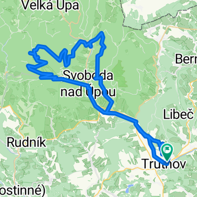
Okruh přes Stachelberg,úbočí Špičáku a Debrné
A cycling route starting in Trutnov, Královéhradecký kraj, Czechia.
Overview
About this route
Kopcovitá trasa zčásti po asfaltu,zčásti po lesních cestách s nádhernými výhledy do kraje a na Špičák.
- -:--
- Duration
- 38.8 km
- Distance
- 716 m
- Ascent
- 719 m
- Descent
- ---
- Avg. speed
- 657 m
- Max. altitude
Route quality
Waytypes & surfaces along the route
Waytypes
Track
20.1 km
(52 %)
Busy road
7.3 km
(19 %)
Surfaces
Paved
20.1 km
(52 %)
Unpaved
9.5 km
(24 %)
Paved (undefined)
12.1 km
(31 %)
Asphalt
7.9 km
(20 %)
Route highlights
Points of interest along the route

Photo after 1.9 km
výhled na Horní Staré Město

Photo after 3.8 km
chata Vébrovka

Photo after 8.1 km
lom

Photo after 9.6 km
výhled do kraje

Photo after 9.6 km
pevnost Stachelberg

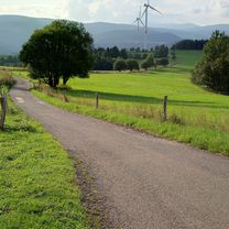
Photo after 16.4 km
železniční viadukt

Photo after 18.4 km
výhled na Špičák

Photo after 24.5 km
výhled do kraje

Photo after 28.3 km
krajina

Photo after 29.2 km

Photo after 29.4 km
výhled na Žacléř

Photo after 29.4 km
odpočivadlo

Photo after 29.8 km
panorama

Photo after 30 km
v pozadí Poříčí

Photo after 32.7 km
Mrtvé jezero

Photo after 36.1 km
sjezd do Voletin
Continue with Bikemap
Use, edit, or download this cycling route
You would like to ride Okruh přes Stachelberg,úbočí Špičáku a Debrné or customize it for your own trip? Here is what you can do with this Bikemap route:
Free features
- Save this route as favorite or in collections
- Copy & plan your own version of this route
- Sync your route with Garmin or Wahoo
Premium features
Free trial for 3 days, or one-time payment. More about Bikemap Premium.
- Navigate this route on iOS & Android
- Export a GPX / KML file of this route
- Create your custom printout (try it for free)
- Download this route for offline navigation
Discover more Premium features.
Get Bikemap PremiumFrom our community
Other popular routes starting in Trutnov
 Okruh přes Bystřici,Rýchorskou boudu a Pilníkov
- Distance
- 50.3 km
- Ascent
- 801 m
- Descent
- 800 m
- Location
- Trutnov, Královéhradecký kraj, Czechia
 Okruh přes Čermnou,Les Království a Žďár
- Distance
- 61.2 km
- Ascent
- 567 m
- Descent
- 568 m
- Location
- Trutnov, Královéhradecký kraj, Czechia
 Okruh přes vrchol Královeckého Špičáku a Debrné
- Distance
- 37 km
- Ascent
- 787 m
- Descent
- 793 m
- Location
- Trutnov, Královéhradecký kraj, Czechia
 Okruh přes Radvanice,Horní Kostelec a Lhotu
- Distance
- 54.2 km
- Ascent
- 683 m
- Descent
- 697 m
- Location
- Trutnov, Královéhradecký kraj, Czechia
 Tour de Krkonoše 2008
- Distance
- 80.2 km
- Ascent
- 2,010 m
- Descent
- 1,974 m
- Location
- Trutnov, Královéhradecký kraj, Czechia
 Okruh přes Ratibořice,Devět křížů a Lhotu
- Distance
- 66.8 km
- Ascent
- 577 m
- Descent
- 577 m
- Location
- Trutnov, Královéhradecký kraj, Czechia
 Okruh přes Černou Horu,Horní Maršov a Antonínovo údolí
- Distance
- 57 km
- Ascent
- 1,122 m
- Descent
- 1,122 m
- Location
- Trutnov, Královéhradecký kraj, Czechia
 Olešňák
- Distance
- 23.8 km
- Ascent
- 347 m
- Descent
- 347 m
- Location
- Trutnov, Královéhradecký kraj, Czechia
Open it in the app