

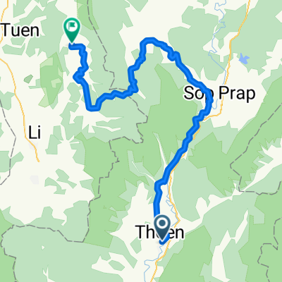
J13 - Thoen - LI
A cycling route starting in Thoen, Lampang, Thailand.
Overview
About this route
Excellent and very pleasant route. The climb is about 20 km long, interrupted by flat sections and descents.
- -:--
- Duration
- 52.9 km
- Distance
- 527 m
- Ascent
- 244 m
- Descent
- ---
- Avg. speed
- ---
- Max. altitude
Continue with Bikemap
Use, edit, or download this cycling route
You would like to ride J13 - Thoen - LI or customize it for your own trip? Here is what you can do with this Bikemap route:
Free features
- Save this route as favorite or in collections
- Copy & plan your own version of this route
- Sync your route with Garmin or Wahoo
Premium features
Free trial for 3 days, or one-time payment. More about Bikemap Premium.
- Navigate this route on iOS & Android
- Export a GPX / KML file of this route
- Create your custom printout (try it for free)
- Download this route for offline navigation
Discover more Premium features.
Get Bikemap PremiumFrom our community
Other popular routes starting in Thoen
 Thailand Tour Stage #12 Thoen - Pa Phlu 100Km 900Hm
- Distance
- 106.5 km
- Ascent
- 1,280 m
- Descent
- 1,082 m
- Location
- Thoen, Lampang, Thailand
 9 From Thoen to Thung Hua Chang
- Distance
- 115.1 km
- Ascent
- 1,499 m
- Descent
- 1,105 m
- Location
- Thoen, Lampang, Thailand
 Dag12 Thoen- Bang Wang Din 53km
- Distance
- 53.2 km
- Ascent
- 926 m
- Descent
- 641 m
- Location
- Thoen, Lampang, Thailand
 Chiang Mai - Uttaradit via Satchanalai
- Distance
- 152.5 km
- Ascent
- 355 m
- Descent
- 462 m
- Location
- Thoen, Lampang, Thailand
 ตำบลล้อมแรด เถิน to Siritwatresort บ้านตาก ตาก
- Distance
- 84.3 km
- Ascent
- 601 m
- Descent
- 643 m
- Location
- Thoen, Lampang, Thailand
 Thailand Tour Stage #7 Amphoe Thoen, Lampang - Sukhothai
- Distance
- 120.7 km
- Ascent
- 287 m
- Descent
- 407 m
- Location
- Thoen, Lampang, Thailand
 ทางหลวงชนบท ลป.3021 135, ตำบล นาโป่ง to ทางหลวงชนบท ลป.3021 135, ตำบล นาโป่ง
- Distance
- 12 km
- Ascent
- 172 m
- Descent
- 171 m
- Location
- Thoen, Lampang, Thailand
 J13 - Thoen - LI
- Distance
- 52.9 km
- Ascent
- 527 m
- Descent
- 244 m
- Location
- Thoen, Lampang, Thailand
Open it in the app