

Aussichten in die Wetterau
A cycling route starting in Butzbach, Hesse, Germany.
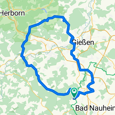
Overview
About this route
The route leads from Butzbach through the Griedelerwald to Holzheim, Oberhörgern, Münzenberg, Rockenberg, Oppershofen, Niederweisel back to Butzbach. Total length 31 km. Light to moderate inclines.
What is there to see?
Butzbach marketplace, Limes UNESCO World Heritage, Münzenberg Castle, salt meadows, Rockenberg's Marienkirche, Niederweisel's Comturkirche, and lots of views over Wetterau, Münzenberg Castle, Vogelsberg and Taunus.
There are plenty of resting opportunities in the villages.
A nice tour for Sunday morning or afternoon.
- -:--
- Duration
- 30.6 km
- Distance
- 250 m
- Ascent
- 250 m
- Descent
- ---
- Avg. speed
- ---
- Max. altitude

Route quality
Waytypes & surfaces along the route
Waytypes
Track
20.5 km
(67 %)
Quiet road
7 km
(23 %)
Surfaces
Paved
21.1 km
(69 %)
Unpaved
5.8 km
(19 %)
Asphalt
15 km
(49 %)
Paved (undefined)
4.9 km
(16 %)
Route highlights
Points of interest along the route
Point of interest after 6.9 km
Limes Weltkulturerbe
Point of interest after 9.4 km
Aussichtspunkt
Point of interest after 14.7 km
Salzwiesen
Point of interest after 15 km
Geologischer Garten
Point of interest after 16.9 km
Burg Münzenberg
Point of interest after 18.1 km
Galgen
Point of interest after 21 km
Rotes Haus
Point of interest after 21 km
Marienkirch, kann leider nicht besichtigt werden ist innerhalb der JVA
Point of interest after 27.7 km
Komturkirche (Malteser Ritterorden)
Point of interest after 30.6 km
Schöner Marktplatz mit Fachwerkhäusern
Continue with Bikemap
Use, edit, or download this cycling route
You would like to ride Aussichten in die Wetterau or customize it for your own trip? Here is what you can do with this Bikemap route:
Free features
- Save this route as favorite or in collections
- Copy & plan your own version of this route
- Sync your route with Garmin or Wahoo
Premium features
Free trial for 3 days, or one-time payment. More about Bikemap Premium.
- Navigate this route on iOS & Android
- Export a GPX / KML file of this route
- Create your custom printout (try it for free)
- Download this route for offline navigation
Discover more Premium features.
Get Bikemap PremiumFrom our community
Other popular routes starting in Butzbach
 RTF Mittelhessen-Abschlussrunde 112 km
- Distance
- 112.8 km
- Ascent
- 724 m
- Descent
- 724 m
- Location
- Butzbach, Hesse, Germany
 Butzbachs Osten
- Distance
- 24 km
- Ascent
- 145 m
- Descent
- 161 m
- Location
- Butzbach, Hesse, Germany
 RTF RV Hoch-Weisel Tour 3
- Distance
- 74.8 km
- Ascent
- 589 m
- Descent
- 586 m
- Location
- Butzbach, Hesse, Germany
 151213 BBWT 20-400
- Distance
- 20.6 km
- Ascent
- 419 m
- Descent
- 420 m
- Location
- Butzbach, Hesse, Germany
 RTF 48 km Herbst 2008
- Distance
- 47.9 km
- Ascent
- 332 m
- Descent
- 332 m
- Location
- Butzbach, Hesse, Germany
 151115 BBWT 24 km 490 HM
- Distance
- 23.8 km
- Ascent
- 506 m
- Descent
- 506 m
- Location
- Butzbach, Hesse, Germany
 151213 BBWT 16 km 300 HM
- Distance
- 16 km
- Ascent
- 333 m
- Descent
- 332 m
- Location
- Butzbach, Hesse, Germany
 RTF Hoch-Weisel Tour 4
- Distance
- 40.1 km
- Ascent
- 327 m
- Descent
- 326 m
- Location
- Butzbach, Hesse, Germany
Open it in the app