

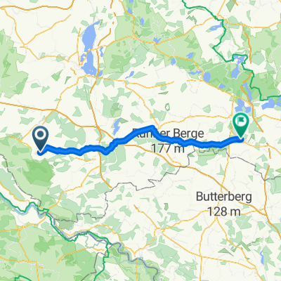
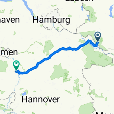
TRV 2013 dag 2
A cycling route starting in Lübtheen, Mecklenburg-Vorpommern, Germany.
Overview
About this route
Dag 2
- -:--
- Duration
- 176.4 km
- Distance
- 382 m
- Ascent
- 378 m
- Descent
- ---
- Avg. speed
- ---
- Max. altitude

Route quality
Waytypes & surfaces along the route
Waytypes
Road
42.3 km
(24 %)
Path
33.5 km
(19 %)
Surfaces
Paved
135.8 km
(77 %)
Unpaved
1.8 km
(1 %)
Asphalt
128.8 km
(73 %)
Concrete
7.1 km
(4 %)
Route highlights
Points of interest along the route
Point of interest after 59.8 km
Stopp 1 dag 3
Point of interest after 115.9 km
Stopp 2 dag 3
Continue with Bikemap
Use, edit, or download this cycling route
You would like to ride TRV 2013 dag 2 or customize it for your own trip? Here is what you can do with this Bikemap route:
Free features
- Save this route as favorite or in collections
- Copy & plan your own version of this route
- Split it into stages to create a multi-day tour
- Sync your route with Garmin or Wahoo
Premium features
Free trial for 3 days, or one-time payment. More about Bikemap Premium.
- Navigate this route on iOS & Android
- Export a GPX / KML file of this route
- Create your custom printout (try it for free)
- Download this route for offline navigation
Discover more Premium features.
Get Bikemap PremiumFrom our community
Other popular routes starting in Lübtheen
 02 von Redefin nach Stuer
- Distance
- 87.6 km
- Ascent
- 151 m
- Descent
- 94 m
- Location
- Lübtheen, Mecklenburg-Vorpommern, Germany
 TRV 2013 dag 2
- Distance
- 176.4 km
- Ascent
- 382 m
- Descent
- 378 m
- Location
- Lübtheen, Mecklenburg-Vorpommern, Germany
 Häuslerei 8, Vellahn nach Feldstraße 8, Vellahn
- Distance
- 24.3 km
- Ascent
- 222 m
- Descent
- 259 m
- Location
- Lübtheen, Mecklenburg-Vorpommern, Germany
 Lübtheen -> Neu Lübtheen -> Jessenitz -> Lübtheen (Sportplatz)
- Distance
- 11.7 km
- Ascent
- 25 m
- Descent
- 24 m
- Location
- Lübtheen, Mecklenburg-Vorpommern, Germany
 Vielanker Brauhaus - Marschacht
- Distance
- 73.5 km
- Ascent
- 130 m
- Descent
- 135 m
- Location
- Lübtheen, Mecklenburg-Vorpommern, Germany
 Vielank1
- Distance
- 22.3 km
- Ascent
- 42 m
- Descent
- 43 m
- Location
- Lübtheen, Mecklenburg-Vorpommern, Germany
 Zur Elbe
- Distance
- 41.5 km
- Ascent
- 51 m
- Descent
- 54 m
- Location
- Lübtheen, Mecklenburg-Vorpommern, Germany
 Vielank-Zarrentin
- Distance
- 51.1 km
- Ascent
- 110 m
- Descent
- 87 m
- Location
- Lübtheen, Mecklenburg-Vorpommern, Germany
Open it in the app