

Landschaftsrunde
A cycling route starting in Surberg, Bavaria, Germany.
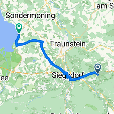
Overview
About this route
A nice route for me, a stop at the Landgasthof Schweizerhof, with the voucher book (2x meals 1x pay) at around km 9-12 along a beautiful creek valley, passing by the chapel of Maria Tann, then at km 17 rolling over an open area towards Lauter
Tip when stopping, ride in the opposite direction
- -:--
- Duration
- 21.8 km
- Distance
- 258 m
- Ascent
- 266 m
- Descent
- ---
- Avg. speed
- ---
- Max. altitude

Route quality
Waytypes & surfaces along the route
Waytypes
Quiet road
16.4 km
(75 %)
Track
5 km
(23 %)
Surfaces
Paved
14 km
(64 %)
Unpaved
4.1 km
(19 %)
Asphalt
12.9 km
(59 %)
Unpaved (undefined)
2.6 km
(12 %)
Continue with Bikemap
Use, edit, or download this cycling route
You would like to ride Landschaftsrunde or customize it for your own trip? Here is what you can do with this Bikemap route:
Free features
- Save this route as favorite or in collections
- Copy & plan your own version of this route
- Sync your route with Garmin or Wahoo
Premium features
Free trial for 3 days, or one-time payment. More about Bikemap Premium.
- Navigate this route on iOS & Android
- Export a GPX / KML file of this route
- Create your custom printout (try it for free)
- Download this route for offline navigation
Discover more Premium features.
Get Bikemap PremiumFrom our community
Other popular routes starting in Surberg
 xc neukirchen
- Distance
- 7.7 km
- Ascent
- 127 m
- Descent
- 127 m
- Location
- Surberg, Bavaria, Germany
 Surberg - Salzburg
- Distance
- 37.8 km
- Ascent
- 171 m
- Descent
- 318 m
- Location
- Surberg, Bavaria, Germany
 Traunstein nach Eugen-Rosner-Straße 15, Traunstein
- Distance
- 19.6 km
- Ascent
- 519 m
- Descent
- 582 m
- Location
- Surberg, Bavaria, Germany
 Landschaftsrunde
- Distance
- 21.8 km
- Ascent
- 258 m
- Descent
- 266 m
- Location
- Surberg, Bavaria, Germany
 9. nach Hause, Berchtesgaden
- Distance
- 57.7 km
- Ascent
- 457 m
- Descent
- 405 m
- Location
- Surberg, Bavaria, Germany
 Vogling-Chieming
- Distance
- 21.4 km
- Ascent
- 112 m
- Descent
- 254 m
- Location
- Surberg, Bavaria, Germany
 Berchtesgardener Land
- Distance
- 55.1 km
- Ascent
- 462 m
- Descent
- 426 m
- Location
- Surberg, Bavaria, Germany
 Holneich nach Kirchplatz
- Distance
- 39.5 km
- Ascent
- 229 m
- Descent
- 355 m
- Location
- Surberg, Bavaria, Germany
Open it in the app