
2005_6 Trondheim_Travemünde
A cycling route starting in Stenungsund, Västra Götaland County, Sweden.
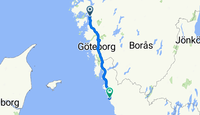
Overview
About this route
Trondheim_Travemuende
- -:--
- Duration
- 130.4 km
- Distance
- 846 m
- Ascent
- 841 m
- Descent
- ---
- Avg. speed
- 103 m
- Max. altitude
Route quality
Waytypes & surfaces along the route
Waytypes
Path
23.5 km
(18 %)
Road
20.9 km
(16 %)
Surfaces
Paved
125.2 km
(96 %)
Asphalt
123.9 km
(95 %)
Paved (undefined)
1.3 km
(1 %)
Undefined
5.2 km
(4 %)
Continue with Bikemap
Use, edit, or download this cycling route
You would like to ride 2005_6 Trondheim_Travemünde or customize it for your own trip? Here is what you can do with this Bikemap route:
Free features
- Save this route as favorite or in collections
- Copy & plan your own version of this route
- Split it into stages to create a multi-day tour
- Sync your route with Garmin or Wahoo
Premium features
Free trial for 3 days, or one-time payment. More about Bikemap Premium.
- Navigate this route on iOS & Android
- Export a GPX / KML file of this route
- Create your custom printout (try it for free)
- Download this route for offline navigation
Discover more Premium features.
Get Bikemap PremiumFrom our community
Other popular routes starting in Stenungsund
 B-O 24 Stenungsund - Noesund
- Distance
- 38.7 km
- Ascent
- 280 m
- Descent
- 282 m
- Location
- Stenungsund, Västra Götaland County, Sweden
 Dag 2 30/4
- Distance
- 54.3 km
- Ascent
- 319 m
- Descent
- 312 m
- Location
- Stenungsund, Västra Götaland County, Sweden
 Stenungsund - Göteborg
- Distance
- 70.1 km
- Ascent
- 331 m
- Descent
- 341 m
- Location
- Stenungsund, Västra Götaland County, Sweden
 ostsee20-26 Stenungsund - Göteborg
- Distance
- 61.1 km
- Ascent
- 419 m
- Descent
- 419 m
- Location
- Stenungsund, Västra Götaland County, Sweden
 C K3 Stenungsund - Göteborg
- Distance
- 157.1 km
- Ascent
- 1,146 m
- Descent
- 1,148 m
- Location
- Stenungsund, Västra Götaland County, Sweden
 Sommertraum 8 Stenungsund - Rörbäck
- Distance
- 66.1 km
- Ascent
- 338 m
- Descent
- 340 m
- Location
- Stenungsund, Västra Götaland County, Sweden
 Stenungsund nach Lysekil
- Distance
- 72.9 km
- Ascent
- 386 m
- Descent
- 391 m
- Location
- Stenungsund, Västra Götaland County, Sweden
 Stenungsund loop
- Distance
- 91.2 km
- Ascent
- 571 m
- Descent
- 586 m
- Location
- Stenungsund, Västra Götaland County, Sweden
Open it in the app