

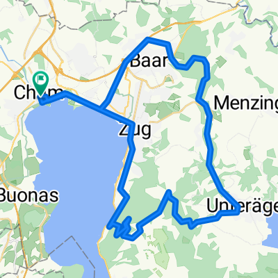
Lindenberg - Schongau - Reusstal
A cycling route starting in Cham, Canton of Zug, Switzerland.
Overview
About this route
Route far from motorized traffic. It leads through beautiful landscapes with views of the Reuss Valley, the Alps, and the Lucerne Seetal. Less than 2 km run along main roads.
Total 720 meters of elevation.
- -:--
- Duration
- 71 km
- Distance
- 840 m
- Ascent
- 826 m
- Descent
- ---
- Avg. speed
- 809 m
- Max. altitude
Route quality
Waytypes & surfaces along the route
Waytypes
Quiet road
34.8 km
(49 %)
Track
14.2 km
(20 %)
Surfaces
Paved
32.7 km
(46 %)
Unpaved
0.7 km
(1 %)
Asphalt
24.2 km
(34 %)
Paved (undefined)
8.5 km
(12 %)
Continue with Bikemap
Use, edit, or download this cycling route
You would like to ride Lindenberg - Schongau - Reusstal or customize it for your own trip? Here is what you can do with this Bikemap route:
Free features
- Save this route as favorite or in collections
- Copy & plan your own version of this route
- Sync your route with Garmin or Wahoo
Premium features
Free trial for 3 days, or one-time payment. More about Bikemap Premium.
- Navigate this route on iOS & Android
- Export a GPX / KML file of this route
- Create your custom printout (try it for free)
- Download this route for offline navigation
Discover more Premium features.
Get Bikemap PremiumFrom our community
Other popular routes starting in Cham
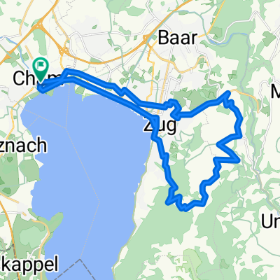
 Zugersee-Lauerzersee-Bibersee
- Distance
- 75.1 km
- Ascent
- 797 m
- Descent
- 796 m
- Location
- Cham, Canton of Zug, Switzerland
 Cham - Ägeri - Zugerberg - Cham
- Distance
- 40.1 km
- Ascent
- 581 m
- Descent
- 581 m
- Location
- Cham, Canton of Zug, Switzerland
 Lindenberg - Schongau - Reusstal
- Distance
- 71.1 km
- Ascent
- 628 m
- Descent
- 628 m
- Location
- Cham, Canton of Zug, Switzerland
 MORGARTEN MEMORIAL 2017
- Distance
- 43.5 km
- Ascent
- 571 m
- Descent
- 571 m
- Location
- Cham, Canton of Zug, Switzerland
 Cham-Ballwil-Sins-Cham
- Distance
- 47 km
- Ascent
- 194 m
- Descent
- 301 m
- Location
- Cham, Canton of Zug, Switzerland
 Cham - Zugerberg
- Distance
- 26.1 km
- Ascent
- 546 m
- Descent
- 546 m
- Location
- Cham, Canton of Zug, Switzerland
 Rigi Kulm - Cham
- Distance
- 63.6 km
- Ascent
- 1,427 m
- Descent
- 1,437 m
- Location
- Cham, Canton of Zug, Switzerland
 Cham-Rotkreuz-Reuss-Cham
- Distance
- 26.1 km
- Ascent
- 122 m
- Descent
- 122 m
- Location
- Cham, Canton of Zug, Switzerland
Open it in the app