

Nette Samstagsrunde
A cycling route starting in Kirchzarten, Baden-Wurttemberg, Germany.
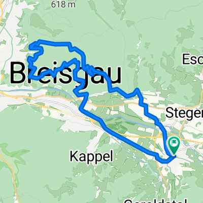
Overview
About this route
3 Anstiege:
Au => Sölden => Geiersnest
Bohrer => Schauinsland
Buchenbach => St. Märgen
- -:--
- Duration
- 91.2 km
- Distance
- 2,638 m
- Ascent
- 2,582 m
- Descent
- ---
- Avg. speed
- 1,197 m
- Max. altitude
Route quality
Waytypes & surfaces along the route
Waytypes
Busy road
55.5 km
(61 %)
Road
16 km
(18 %)
Surfaces
Paved
86 km
(94 %)
Unpaved
0.6 km
(<1 %)
Asphalt
83.4 km
(91 %)
Paved (undefined)
2.3 km
(3 %)
Continue with Bikemap
Use, edit, or download this cycling route
You would like to ride Nette Samstagsrunde or customize it for your own trip? Here is what you can do with this Bikemap route:
Free features
- Save this route as favorite or in collections
- Copy & plan your own version of this route
- Split it into stages to create a multi-day tour
- Sync your route with Garmin or Wahoo
Premium features
Free trial for 3 days, or one-time payment. More about Bikemap Premium.
- Navigate this route on iOS & Android
- Export a GPX / KML file of this route
- Create your custom printout (try it for free)
- Download this route for offline navigation
Discover more Premium features.
Get Bikemap PremiumFrom our community
Other popular routes starting in Kirchzarten
 Nette Samstagsrunde
- Distance
- 91.2 km
- Ascent
- 2,638 m
- Descent
- 2,582 m
- Location
- Kirchzarten, Baden-Wurttemberg, Germany
 Wendelinskappele - St.Ottilientour
- Distance
- 25.3 km
- Ascent
- 513 m
- Descent
- 512 m
- Location
- Kirchzarten, Baden-Wurttemberg, Germany
 Tunibergrunde
- Distance
- 64.6 km
- Ascent
- 230 m
- Descent
- 230 m
- Location
- Kirchzarten, Baden-Wurttemberg, Germany
 Kleine Sternwald Tour CLONED FROM ROUTE 97012
- Distance
- 16.7 km
- Ascent
- 631 m
- Descent
- 630 m
- Location
- Kirchzarten, Baden-Wurttemberg, Germany
 Zarten - St. Märgen - Zarten
- Distance
- 34.3 km
- Ascent
- 835 m
- Descent
- 803 m
- Location
- Kirchzarten, Baden-Wurttemberg, Germany
 Ultrabike Black Forest. Proberunde
- Distance
- 115.5 km
- Ascent
- 2,396 m
- Descent
- 2,396 m
- Location
- Kirchzarten, Baden-Wurttemberg, Germany
 Route Black Forest Ultra Bike (ULTRA - 116 km)
- Distance
- 109.8 km
- Ascent
- 2,198 m
- Descent
- 2,190 m
- Location
- Kirchzarten, Baden-Wurttemberg, Germany
 Kleine Sternwald Tour die Dritte
- Distance
- 28.5 km
- Ascent
- 919 m
- Descent
- 940 m
- Location
- Kirchzarten, Baden-Wurttemberg, Germany
Open it in the app