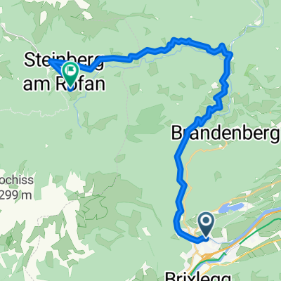
Rofanumrundung
A cycling route starting in Kramsach, Tyrol, Austria.
Overview
About this route
A beautiful and varied cycling tour around the Rofanstock.
In principle, you can start the loop anywhere; I chose the parking lot at Sport-Ossi in Kramsach as the starting point, because this way the steep climbs come at the beginning of the tour, and later on, when it gets warmer, you can enjoy rolling pleasantly along Achensee and descending again.
On the descent, starting from the hairpin, I marked a shortcut through the forest—there's about 500m where you have to push your bike, so technically it would be quicker to shoot down into the valley via the main road, but the forest path is quite nice.
- -:--
- Duration
- 63.1 km
- Distance
- 1,047 m
- Ascent
- 1,037 m
- Descent
- ---
- Avg. speed
- ---
- Max. altitude
Route quality
Waytypes & surfaces along the route
Waytypes
Quiet road
20.2 km
(32 %)
Road
19.6 km
(31 %)
Surfaces
Paved
38.5 km
(61 %)
Unpaved
8.2 km
(13 %)
Asphalt
37.8 km
(60 %)
Gravel
6.9 km
(11 %)
Continue with Bikemap
Use, edit, or download this cycling route
You would like to ride Rofanumrundung or customize it for your own trip? Here is what you can do with this Bikemap route:
Free features
- Save this route as favorite or in collections
- Copy & plan your own version of this route
- Sync your route with Garmin or Wahoo
Premium features
Free trial for 3 days, or one-time payment. More about Bikemap Premium.
- Navigate this route on iOS & Android
- Export a GPX / KML file of this route
- Create your custom printout (try it for free)
- Download this route for offline navigation
Discover more Premium features.
Get Bikemap PremiumFrom our community
Other popular routes starting in Kramsach
- Rofanumrundung
- Distance
- 63.1 km
- Ascent
- 1,047 m
- Descent
- 1,037 m
- Location
- Kramsach, Tyrol, Austria
- Kramsach-Oberaudorf-Kramsach
- Distance
- 86.6 km
- Ascent
- 385 m
- Descent
- 385 m
- Location
- Kramsach, Tyrol, Austria
- Seenrunde ab Kramsach
- Distance
- 7.1 km
- Ascent
- 130 m
- Descent
- 130 m
- Location
- Kramsach, Tyrol, Austria
- Kramsach-Wörgl-Hopfgarten-Itter-Söll-Häring-Angerberg-Kramsach
- Distance
- 75.2 km
- Ascent
- 670 m
- Descent
- 670 m
- Location
- Kramsach, Tyrol, Austria
- Kramsach-Holzalm-Schatzberg-Mühlau-Kundl-Kramsach
- Distance
- 57.4 km
- Ascent
- 1,972 m
- Descent
- 1,972 m
- Location
- Kramsach, Tyrol, Austria
- Kramsach - Breitenbach
- Distance
- 18.7 km
- Ascent
- 97 m
- Descent
- 97 m
- Location
- Kramsach, Tyrol, Austria
- Voldöpper Spitze (1509 m), Wanderung
- Distance
- 4.6 km
- Ascent
- 927 m
- Descent
- 17 m
- Location
- Kramsach, Tyrol, Austria
- Kramsach-Hochfügen-Loas-Schwaz-retour
- Distance
- 65.2 km
- Ascent
- 1,179 m
- Descent
- 1,179 m
- Location
- Kramsach, Tyrol, Austria
Open it in the app