

tolerančná lipa
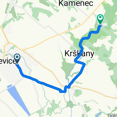
A cycling route starting in Levice, Nitra Region, Slovakia.
Overview
About this route
The route runs along side roads, with two legally protected trees on the way. The bark of the tolerance lime is on the jerseys of our cycling group. The road down the valley from Jabloňovce to Dekýš is in poor asphalt condition, and the road in the upper part of the Voznicka valley is also poor. The section from Hr. Beňadika to Tlmače is narrow and busy.
- -:--
- Duration
- 83.1 km
- Distance
- 591 m
- Ascent
- 591 m
- Descent
- ---
- Avg. speed
- ---
- Max. altitude

Route quality
Waytypes & surfaces along the route
Waytypes
Road
22.4 km
(27 %)
Quiet road
15.8 km
(19 %)
Surfaces
Paved
49.8 km
(60 %)
Unpaved
4.2 km
(5 %)
Asphalt
48.2 km
(58 %)
Unpaved (undefined)
2.5 km
(3 %)
Route highlights
Points of interest along the route
Point of interest after 20.8 km
Tolerančná lipa - tristo rokov starý strom zasadený na počesť Tolerančného patentu Jozefa II.z roku 1781 , ktorým bola vyhlásená obmedzená náboženská sloboda a občianska rovnoprávnosť
Continue with Bikemap
Use, edit, or download this cycling route
You would like to ride tolerančná lipa or customize it for your own trip? Here is what you can do with this Bikemap route:
Free features
- Save this route as favorite or in collections
- Copy & plan your own version of this route
- Split it into stages to create a multi-day tour
- Sync your route with Garmin or Wahoo
Premium features
Free trial for 3 days, or one-time payment. More about Bikemap Premium.
- Navigate this route on iOS & Android
- Export a GPX / KML file of this route
- Create your custom printout (try it for free)
- Download this route for offline navigation
Discover more Premium features.
Get Bikemap PremiumFrom our community
Other popular routes starting in Levice
 Zuhra cez Svaty Kriz
- Distance
- 37.6 km
- Ascent
- 445 m
- Descent
- 486 m
- Location
- Levice, Nitra Region, Slovakia
 Siklós
- Distance
- 10.2 km
- Ascent
- 191 m
- Descent
- 151 m
- Location
- Levice, Nitra Region, Slovakia
 Levice - Dolná Seč - Kalná nad Hronom - Starý Tekov - Tlmače
- Distance
- 24 km
- Ascent
- 42 m
- Descent
- 30 m
- Location
- Levice, Nitra Region, Slovakia
 Levice - Staré Levice - Veľké Krškany - Horša
- Distance
- 11.3 km
- Ascent
- 111 m
- Descent
- 95 m
- Location
- Levice, Nitra Region, Slovakia
 Levice-Dol.Seč- Kalná n. Hronom- Starý Tekov
- Distance
- 20.8 km
- Ascent
- 58 m
- Descent
- 49 m
- Location
- Levice, Nitra Region, Slovakia
 Pohronská magistrála
- Distance
- 36 km
- Ascent
- 180 m
- Descent
- 182 m
- Location
- Levice, Nitra Region, Slovakia
 Extrem Tri vrchy
- Distance
- 166.3 km
- Ascent
- 2,904 m
- Descent
- 2,904 m
- Location
- Levice, Nitra Region, Slovakia
 Levice-N.Dedina- Devičany- Bátovce v.n.
- Distance
- 27.6 km
- Ascent
- 428 m
- Descent
- 359 m
- Location
- Levice, Nitra Region, Slovakia
Open it in the app