

Glen Cove Loop
A cycling route starting in Crockett, California, United States.
Overview
About this route
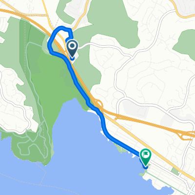
Experience this relatively short loop around the southwestern part of Vallejo and east end of Benicia.
The trip stages at the new and contravercial Glen Cove Waterfront Park, where you'll ride one of the newest stretches of the SF Bay Trail, a loosely paved/tightly packed gravel path along the western end of the park, turning south toward Benicia State Recreational Park.
Near the end of the paved road, you'll merge onto a dirt path leading into the State Park, where you'll climb a few hills in a northeast direction, eventually riding the flat, paved Dillon Point Road along Southampton Bay.
Once you reach the main entrance to the park, you'll cross the new cycle overpass over I-780 and begin to return to Glen Cove via. Columbus Parkway and Benicia Road.
Turning left onto Glen Cove Parkway, you continue your steady climb along the bike path, before going completely downhill all the way back to where you started.
- -:--
- Duration
- 8.6 km
- Distance
- 144 m
- Ascent
- 142 m
- Descent
- ---
- Avg. speed
- ---
- Max. altitude
Route quality
Waytypes & surfaces along the route
Waytypes
Busy road
3.7 km
(43 %)
Cycleway
1.8 km
(21 %)
Surfaces
Paved
2.1 km
(24 %)
Unpaved
0.9 km
(10 %)
Asphalt
1.5 km
(17 %)
Concrete
0.5 km
(6 %)
Continue with Bikemap
Use, edit, or download this cycling route
You would like to ride Glen Cove Loop or customize it for your own trip? Here is what you can do with this Bikemap route:
Free features
- Save this route as favorite or in collections
- Copy & plan your own version of this route
- Sync your route with Garmin or Wahoo
Premium features
Free trial for 3 days, or one-time payment. More about Bikemap Premium.
- Navigate this route on iOS & Android
- Export a GPX / KML file of this route
- Create your custom printout (try it for free)
- Download this route for offline navigation
Discover more Premium features.
Get Bikemap PremiumFrom our community
Other popular routes starting in Crockett
 Part 2 Crockett Ride
- Distance
- 24.8 km
- Ascent
- 247 m
- Descent
- 328 m
- Location
- Crockett, California, United States
 bridge to bridge Benicia State Park
- Distance
- 40.3 km
- Ascent
- 516 m
- Descent
- 515 m
- Location
- Crockett, California, United States
 Route to 1700 Nevin Ave, Richmond
- Distance
- 23.7 km
- Ascent
- 220 m
- Descent
- 230 m
- Location
- Crockett, California, United States
 Route from I-780 W, Benicia
- Distance
- 4 km
- Ascent
- 17 m
- Descent
- 26 m
- Location
- Crockett, California, United States
 Glen Cove Loop
- Distance
- 8.6 km
- Ascent
- 144 m
- Descent
- 142 m
- Location
- Crockett, California, United States
 Blistering ride in Benicia
- Distance
- 55.3 km
- Ascent
- 5 m
- Descent
- 40 m
- Location
- Crockett, California, United States
 Martinez Loop
- Distance
- 38 km
- Ascent
- 334 m
- Descent
- 345 m
- Location
- Crockett, California, United States
 High-speed route in American Canyon
- Distance
- 64.5 km
- Ascent
- 25 m
- Descent
- 64 m
- Location
- Crockett, California, United States
Open it in the app