
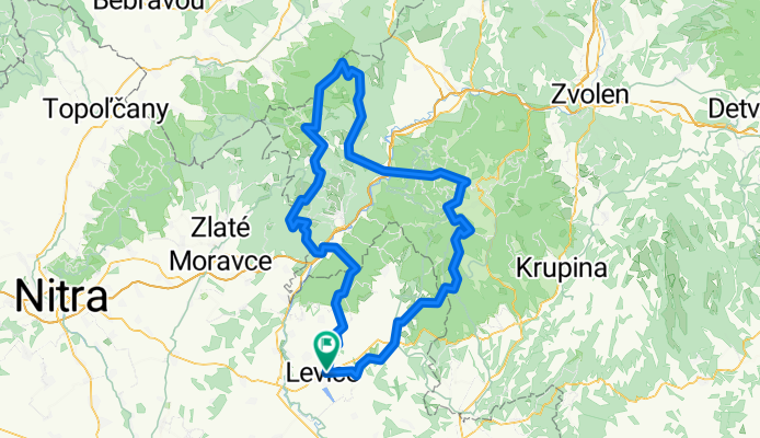
Extrem Tri vrchy
A cycling route starting in Levice, Nitra Region, Slovakia.
Overview
About this route
Very challenging route, you need to start out in the dark during summer when the days are longest. I recommend riding the route in sections beforehand. The name of the route indicates that the biker climbs the three highest peaks in our vicinity in one day: Veľký Inovec, Vtáčnik, Sitno.
- -:--
- Duration
- 166.3 km
- Distance
- 2,904 m
- Ascent
- 2,904 m
- Descent
- ---
- Avg. speed
- ---
- Max. altitude

Route highlights
Points of interest along the route
Point of interest after 37.7 km
Veľký Inovec ,900 mnm
Point of interest after 47.8 km
Vojšín ,818,9 m n.m.
Point of interest after 48.7 km
zjazdova trať ==MASTALBIKERS==
Point of interest after 70.2 km
Vtáčnik ,1345 m.n.m.
Point of interest after 124.2 km
Sitno , 1009 m.n.m
Continue with Bikemap
Use, edit, or download this cycling route
You would like to ride Extrem Tri vrchy or customize it for your own trip? Here is what you can do with this Bikemap route:
Free features
- Save this route as favorite or in collections
- Copy & plan your own version of this route
- Split it into stages to create a multi-day tour
- Sync your route with Garmin or Wahoo
Premium features
Free trial for 3 days, or one-time payment. More about Bikemap Premium.
- Navigate this route on iOS & Android
- Export a GPX / KML file of this route
- Create your custom printout (try it for free)
- Download this route for offline navigation
Discover more Premium features.
Get Bikemap PremiumFrom our community
Other popular routes starting in Levice
 časovka do vrchu Tlstý vrch
- Distance
- 6.7 km
- Ascent
- 208 m
- Descent
- 17 m
- Location
- Levice, Nitra Region, Slovakia
 Levice - Staré Levice - Veľké Krškany - Horša
- Distance
- 11.3 km
- Ascent
- 111 m
- Descent
- 95 m
- Location
- Levice, Nitra Region, Slovakia
 Levice-N.Dedina- Devičany- Bátovce v.n.
- Distance
- 27.6 km
- Ascent
- 428 m
- Descent
- 359 m
- Location
- Levice, Nitra Region, Slovakia
 okolo Slovenskej brány
- Distance
- 53.2 km
- Ascent
- 542 m
- Descent
- 540 m
- Location
- Levice, Nitra Region, Slovakia
 Pohronská magistrála
- Distance
- 36 km
- Ascent
- 180 m
- Descent
- 182 m
- Location
- Levice, Nitra Region, Slovakia
 Levice - Dolná Seč - Kalná nad Hronom - Starý Tekov - Tlmače
- Distance
- 24 km
- Ascent
- 42 m
- Descent
- 30 m
- Location
- Levice, Nitra Region, Slovakia
 tolerančná lipa
- Distance
- 83.1 km
- Ascent
- 591 m
- Descent
- 591 m
- Location
- Levice, Nitra Region, Slovakia
 vozokanský lev
- Distance
- 74.8 km
- Ascent
- 282 m
- Descent
- 281 m
- Location
- Levice, Nitra Region, Slovakia
Open it in the app