

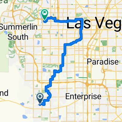
56m RT Mt. Springs, Mt.Potosi.
A cycling route starting in Enterprise, Nevada, United States.
Overview
About this route
Climbing there is a bugger, coming back is a blast!
- -:--
- Duration
- 45.2 km
- Distance
- 980 m
- Ascent
- 90 m
- Descent
- ---
- Avg. speed
- ---
- Max. altitude

Continue with Bikemap
Use, edit, or download this cycling route
You would like to ride 56m RT Mt. Springs, Mt.Potosi. or customize it for your own trip? Here is what you can do with this Bikemap route:
Free features
- Save this route as favorite or in collections
- Copy & plan your own version of this route
- Sync your route with Garmin or Wahoo
Premium features
Free trial for 3 days, or one-time payment. More about Bikemap Premium.
- Navigate this route on iOS & Android
- Export a GPX / KML file of this route
- Create your custom printout (try it for free)
- Download this route for offline navigation
Discover more Premium features.
Get Bikemap PremiumFrom our community
Other popular routes starting in Enterprise
 mountains edge pkwy 4.7
- Distance
- 7.6 km
- Ascent
- 32 m
- Descent
- 32 m
- Location
- Enterprise, Nevada, United States
 Golf Course St, Las Vegas to W Pebble Rd, Las Vegas
- Distance
- 37.9 km
- Ascent
- 139 m
- Descent
- 191 m
- Location
- Enterprise, Nevada, United States
 Topley Pike Avenue 6623, Las Vegas to South Las Vegas Boulevard 5100
- Distance
- 18.5 km
- Ascent
- 41 m
- Descent
- 134 m
- Location
- Enterprise, Nevada, United States
 Maryland
- Distance
- 17.8 km
- Ascent
- 64 m
- Descent
- 191 m
- Location
- Enterprise, Nevada, United States
 Henderson Airport Loop
- Distance
- 13.1 km
- Ascent
- 68 m
- Descent
- 71 m
- Location
- Enterprise, Nevada, United States
 Route from W Mountains Edge Pkwy, Las Vegas
- Distance
- 13.9 km
- Ascent
- 36 m
- Descent
- 93 m
- Location
- Enterprise, Nevada, United States
 Home to work
- Distance
- 29.5 km
- Ascent
- 73 m
- Descent
- 291 m
- Location
- Enterprise, Nevada, United States
 Raiders Way 1415, Henderson to Chaparral Road 1735, Henderson
- Distance
- 102.4 km
- Ascent
- 559 m
- Descent
- 515 m
- Location
- Enterprise, Nevada, United States
Open it in the app