

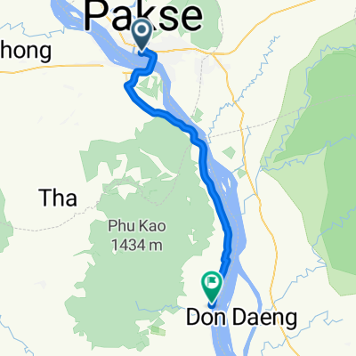
Jour 37 – Paksé – Wat Phu
A cycling route starting in Pakse, Champasak Province, Laos.
Overview
About this route
Day 37 – Pakse – Wat Phu 53 km – average 14.5 km/h almost flat Monday, 18 February 2013
- -:--
- Duration
- 46.5 km
- Distance
- 93 m
- Ascent
- 88 m
- Descent
- ---
- Avg. speed
- ---
- Max. altitude
Continue with Bikemap
Use, edit, or download this cycling route
You would like to ride Jour 37 – Paksé – Wat Phu or customize it for your own trip? Here is what you can do with this Bikemap route:
Free features
- Save this route as favorite or in collections
- Copy & plan your own version of this route
- Sync your route with Garmin or Wahoo
Premium features
Free trial for 3 days, or one-time payment. More about Bikemap Premium.
- Navigate this route on iOS & Android
- Export a GPX / KML file of this route
- Create your custom printout (try it for free)
- Download this route for offline navigation
Discover more Premium features.
Get Bikemap PremiumFrom our community
Other popular routes starting in Pakse
 Route to Th 11, Pakxe
- Distance
- 35.4 km
- Ascent
- 132 m
- Descent
- 142 m
- Location
- Pakse, Champasak Province, Laos
 ປາກເຊ to ປາກເຊ
- Distance
- 17.3 km
- Ascent
- 134 m
- Descent
- 114 m
- Location
- Pakse, Champasak Province, Laos
 1804 Pakse - E Tu Waterfall Lodge
- Distance
- 36 km
- Ascent
- 838 m
- Descent
- 21 m
- Location
- Pakse, Champasak Province, Laos
 Laos : de pakse à Pleikan (vn)
- Distance
- 332.4 km
- Ascent
- 2,551 m
- Descent
- 2,096 m
- Location
- Pakse, Champasak Province, Laos
 1808 Pakse - Champasak
- Distance
- 35.5 km
- Ascent
- 74 m
- Descent
- 71 m
- Location
- Pakse, Champasak Province, Laos
 naar 4000 eilanden
- Distance
- 157.3 km
- Ascent
- 119 m
- Descent
- 130 m
- Location
- Pakse, Champasak Province, Laos
 Bolaven Plateau
- Distance
- 197 km
- Ascent
- 2,092 m
- Descent
- 2,105 m
- Location
- Pakse, Champasak Province, Laos
 Bolaven Plateau
- Distance
- 197.3 km
- Ascent
- 1,751 m
- Descent
- 1,762 m
- Location
- Pakse, Champasak Province, Laos
Open it in the app