

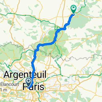
Rallye Alex SINGER - 3 mars 2013
A cycling route starting in Neuilly-sur-Seine, Île-de-France Region, France.
Overview
About this route
The Rallye Singer is on an open route. Nevertheless, over the decades, a preferred itinerary has emerged. This is the one proposed here, up to the Moulin d'Ors. Beyond this point, which is the second control, different variants exist, such as the climb of Villiers-le-Bel, allowing a short incursion into Essonne, then that of l'Homme Mort. The route proposed here follows, over 23km, the itinerary of the 2012 Tour de France, up to Sèvres. Then, after the Parc de Saint-Cloud, the return along the quays, traditional places of the wildest sprints of the SINGER.
- -:--
- Duration
- 69.5 km
- Distance
- 443 m
- Ascent
- 449 m
- Descent
- ---
- Avg. speed
- ---
- Max. altitude

Route quality
Waytypes & surfaces along the route
Waytypes
Quiet road
14.6 km
(21 %)
Road
6.3 km
(9 %)
Surfaces
Paved
61.8 km
(89 %)
Unpaved
0.7 km
(1 %)
Asphalt
58.3 km
(84 %)
Concrete
2.1 km
(3 %)
Continue with Bikemap
Use, edit, or download this cycling route
You would like to ride Rallye Alex SINGER - 3 mars 2013 or customize it for your own trip? Here is what you can do with this Bikemap route:
Free features
- Save this route as favorite or in collections
- Copy & plan your own version of this route
- Sync your route with Garmin or Wahoo
Premium features
Free trial for 3 days, or one-time payment. More about Bikemap Premium.
- Navigate this route on iOS & Android
- Export a GPX / KML file of this route
- Create your custom printout (try it for free)
- Download this route for offline navigation
Discover more Premium features.
Get Bikemap PremiumFrom our community
Other popular routes starting in Neuilly-sur-Seine
 Rue de la Pompe, Paris à Boulevard de Grenelle, Paris
- Distance
- 3.7 km
- Ascent
- 13 m
- Descent
- 31 m
- Location
- Neuilly-sur-Seine, Île-de-France Region, France
 Day 1 - Paris - Orléans
- Distance
- 136.6 km
- Ascent
- 702 m
- Descent
- 657 m
- Location
- Neuilly-sur-Seine, Île-de-France Region, France
 Boulevard Flandrin, Paris à Rue Coypel, Paris
- Distance
- 8.5 km
- Ascent
- 51 m
- Descent
- 55 m
- Location
- Neuilly-sur-Seine, Île-de-France Region, France
 Neuilly-sur-Seine - Compiègne
- Distance
- 99.9 km
- Ascent
- 502 m
- Descent
- 546 m
- Location
- Neuilly-sur-Seine, Île-de-France Region, France
 2019 - CC11 Paris-Versailles-Paris
- Distance
- 59.6 km
- Ascent
- 692 m
- Descent
- 692 m
- Location
- Neuilly-sur-Seine, Île-de-France Region, France
 Tour around Bois de Boulogne 1
- Distance
- 15.3 km
- Ascent
- 168 m
- Descent
- 168 m
- Location
- Neuilly-sur-Seine, Île-de-France Region, France
 Rue Singer, Paris à Avenue de Versailles, Paris
- Distance
- 1.7 km
- Ascent
- 0 m
- Descent
- 21 m
- Location
- Neuilly-sur-Seine, Île-de-France Region, France
 Boulevard Flandrin, Paris à Rue Vivienne, Paris
- Distance
- 6.2 km
- Ascent
- 23 m
- Descent
- 38 m
- Location
- Neuilly-sur-Seine, Île-de-France Region, France
Open it in the app