

Miskolc - Kékestető - Galyatető - Pásztó - Aszód - Gödöllő - Bp
A cycling route starting in Miskolc, Borsod-Abauj Zemplen county, Hungary.
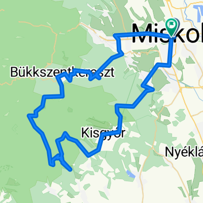
Overview
About this route
2009.05.30. 05:40'~20:40'<br />egy jobbra helyett balra és máris kimaradt Szilvásvárad :)
Bicaj óra szerint: <br />menetidő: 11:51'<br />megtett út: 250.5 km<br />átlag seb: 21,1 km/h<br />max: 62,2<br /><br />se defekt, se eső
- -:--
- Duration
- 235.6 km
- Distance
- 3,605 m
- Ascent
- 3,568 m
- Descent
- ---
- Avg. speed
- 995 m
- Max. altitude

Route quality
Waytypes & surfaces along the route
Waytypes
Quiet road
35.3 km
(15 %)
Track
23.6 km
(10 %)
Surfaces
Paved
136.7 km
(58 %)
Unpaved
14.1 km
(6 %)
Asphalt
136.7 km
(58 %)
Ground
7.1 km
(3 %)
Route highlights
Points of interest along the route
Point of interest after 0 km
start 05:40'
Point of interest after 31.6 km
valahol itt kellett volna inkább jobbra menni...
Point of interest after 33.4 km
Meglepetés ! Miskolc-Eger út Szilvásvárad helyett...
Point of interest after 34.9 km
hoppá, erre Miskolc
Continue with Bikemap
Use, edit, or download this cycling route
You would like to ride Miskolc - Kékestető - Galyatető - Pásztó - Aszód - Gödöllő - Bp or customize it for your own trip? Here is what you can do with this Bikemap route:
Free features
- Save this route as favorite or in collections
- Copy & plan your own version of this route
- Split it into stages to create a multi-day tour
- Sync your route with Garmin or Wahoo
Premium features
Free trial for 3 days, or one-time payment. More about Bikemap Premium.
- Navigate this route on iOS & Android
- Export a GPX / KML file of this route
- Create your custom printout (try it for free)
- Download this route for offline navigation
Discover more Premium features.
Get Bikemap PremiumFrom our community
Other popular routes starting in Miskolc
 KME - Déli Bükk II. 2016
- Distance
- 70.1 km
- Ascent
- 903 m
- Descent
- 900 m
- Location
- Miskolc, Borsod-Abauj Zemplen county, Hungary
 2018.05.05 Mc-Bükkaranyos-Nyékládháza-Ónod-Felsőzsolca-Mc
- Distance
- 66 km
- Ascent
- 190 m
- Descent
- 190 m
- Location
- Miskolc, Borsod-Abauj Zemplen county, Hungary
 Eger-miskolc erdei út
- Distance
- 65.8 km
- Ascent
- 757 m
- Descent
- 718 m
- Location
- Miskolc, Borsod-Abauj Zemplen county, Hungary
 Miskolc-Nyéki tó (István tó)
- Distance
- 45.7 km
- Ascent
- 172 m
- Descent
- 187 m
- Location
- Miskolc, Borsod-Abauj Zemplen county, Hungary
 Miskolc - Lillafüred - Nagy-Mező - Olasz kapu - Szilvási kő - Bánkút - Felső-Borovnyák - Ómassa - Miskolc
- Distance
- 88.2 km
- Ascent
- 1,827 m
- Descent
- 1,827 m
- Location
- Miskolc, Borsod-Abauj Zemplen county, Hungary
 Bringával a Bükk csúcsán 2013.
- Distance
- 61.6 km
- Ascent
- 890 m
- Descent
- 889 m
- Location
- Miskolc, Borsod-Abauj Zemplen county, Hungary
 Miskolc - Lillafüred - Jávorkút - Nagy-mező- Bánkút - Bálvány hegy - Csipkéskút - Ómassa - Miskolc
- Distance
- 82.8 km
- Ascent
- 1,216 m
- Descent
- 1,215 m
- Location
- Miskolc, Borsod-Abauj Zemplen county, Hungary
 KME - Szirt túra I. 2016
- Distance
- 103.9 km
- Ascent
- 1,218 m
- Descent
- 1,213 m
- Location
- Miskolc, Borsod-Abauj Zemplen county, Hungary
Open it in the app