

Steinige Tour (Schleife 1)
A cycling route starting in Bad Steben, Bavaria, Germany.
Overview
About this route
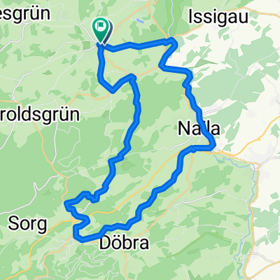
Route Bad Steben - Höllental - Marxgrün - Thierbach - Horwagen - Gerlas - Geroldsgrün - Längenau - Längenautal - Seitental - Buchenwald - Silberstein
Route description We start in Bad Steben from the train station along the railway line towards Hölle (mineral spring), passing the quarry/hard stone works at the Höllental stop. We travel via Marxgrün to Thierbach (watch for car traffic!). From Bobengrün we continue to Horwagen (marble quarry), then to Gerlas (Höllental information centre of the Frankenwald Nature Park) to Geroldsgrün. Now comes a steep climb within the town, followed by a long, steep descent through spruce and beech forests into the Längenau valley. Stop at the Max-Marien spring fountain in Längenau, then continue through the Längenau valley to the next side valley opening right (Hopperlesgrund), follow the stream valley uphill through the beech forest past Hopperles Kohlstatt, following the signage of the Euregio Egrensis long-distance cycle route to Silberstein. (A detour to the Lotharheil slate mine is possible beforehand). Continuing via Neumühle there is a steep climb to Großenreuth (viewpoint!) then to Steinbach near Geroldsgrün. We then cycle further via Obersteben (Alexander-v.-Humboldt-Haus / Old Mining Authority / Forestry Office) back to Bad Steben and the train station.
Difficulty Challenging cycle tour for the sporty touring cyclist requiring good fitness. Long, partly steep climbs (walking the bike is permitted), but also long descents to enjoy.
Possible connecting routes from other tours Euregio-Egrensis cycle path
Train connections Bad Steben
- -:--
- Duration
- 20.5 km
- Distance
- 291 m
- Ascent
- 297 m
- Descent
- ---
- Avg. speed
- ---
- Max. altitude
Route quality
Waytypes & surfaces along the route
Waytypes
Track
7.8 km
(38 %)
Quiet road
4.5 km
(22 %)
Surfaces
Paved
9 km
(44 %)
Unpaved
7 km
(34 %)
Asphalt
9 km
(44 %)
Gravel
4.1 km
(20 %)
Continue with Bikemap
Use, edit, or download this cycling route
You would like to ride Steinige Tour (Schleife 1) or customize it for your own trip? Here is what you can do with this Bikemap route:
Free features
- Save this route as favorite or in collections
- Copy & plan your own version of this route
- Sync your route with Garmin or Wahoo
Premium features
Free trial for 3 days, or one-time payment. More about Bikemap Premium.
- Navigate this route on iOS & Android
- Export a GPX / KML file of this route
- Create your custom printout (try it for free)
- Download this route for offline navigation
Discover more Premium features.
Get Bikemap PremiumFrom our community
Other popular routes starting in Bad Steben
 Die kleine Einführungsrunde
- Distance
- 15.6 km
- Ascent
- 218 m
- Descent
- 185 m
- Location
- Bad Steben, Bavaria, Germany
 Bad Steben-Stadtsteinach-Marktrodch
- Distance
- 106.8 km
- Ascent
- 950 m
- Descent
- 950 m
- Location
- Bad Steben, Bavaria, Germany
 2010 Thüringen, Ostbayern, Böhmen Tag 4
- Distance
- 25.9 km
- Ascent
- 486 m
- Descent
- 457 m
- Location
- Bad Steben, Bavaria, Germany
 04 Bad Steben-Kronach
- Distance
- 42.2 km
- Ascent
- 532 m
- Descent
- 779 m
- Location
- Bad Steben, Bavaria, Germany
 Tour_zur_Kur_HO_12
- Distance
- 34.5 km
- Ascent
- 467 m
- Descent
- 465 m
- Location
- Bad Steben, Bavaria, Germany
 Rennradtour für geübtere Fahrer
- Distance
- 100.6 km
- Ascent
- 1,053 m
- Descent
- 1,180 m
- Location
- Bad Steben, Bavaria, Germany
 Blankenstein - Redwitz an der Rodach
- Distance
- 56.6 km
- Ascent
- 450 m
- Descent
- 758 m
- Location
- Bad Steben, Bavaria, Germany
 Frankenrundfahrt
- Distance
- 107.3 km
- Ascent
- 1,650 m
- Descent
- 1,677 m
- Location
- Bad Steben, Bavaria, Germany
Open it in the app