

Balade au pied du Pic Saint-Loup
A cycling route starting in Grabels, Occitanie, France.
Overview
About this route
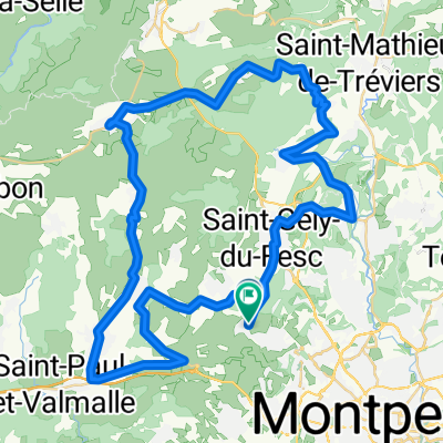
- Start from Grabels, where there are churches from the 13th and 14th centuries to discover (single nave vaulted with ribbed arches and flat apse), then head towards Saint-Gély-du-Fesc (D102).
- At Saint-Gély-du-Fesc, follow the D102 towards Les Matelles.
- At Les Matelles, explore a medieval village (walkable on foot). Then take the D17E3 towards Saint-Mathieu-de-Tréviers.
- Head towards Les Cazarels, Saint-Mathieu-de-Tréviers.
- Leaving the hamlet of Les Cazarels, at the bottom of the descent, turn right onto Chemin des Charretiers (paved) until the intersection with D113E3. There, take the D113 straight ahead towards Saint-Mathieu-de-Tréviers.
- At Saint-Mathieu-de-Tréviers, take the D26 towards Assas, Lac du Ceceles (small detour to the lake possible, unpaved). Then continue on D109 towards Assas.
- At Assas, admire a castle and a 12th-century church. Then take the D109E towards Saint-Vincent-de-Barbeyrargues.
- At Saint-Vincent-de-Barbeyrargues, see another 12th-century church. Continue towards Prades-le-Lez.
- At Prades-le-Lez, continue on the D145 towards Saint-Gély-du-Fesc. At the roundabout at the end of the Allée des platanes, take the cycle path on the left side of the road straight ahead.
- At Saint-Gély-du-Fesc, follow the D127E5 towards Combaillaux / Grabels.
- Continue on D127 until Grabels.
- -:--
- Duration
- 44.8 km
- Distance
- 250 m
- Ascent
- 247 m
- Descent
- ---
- Avg. speed
- ---
- Max. altitude
Route quality
Waytypes & surfaces along the route
Waytypes
Road
36.3 km
(81 %)
Quiet road
2.2 km
(5 %)
Surfaces
Paved
30.9 km
(69 %)
Asphalt
30.9 km
(69 %)
Undefined
13.9 km
(31 %)
Continue with Bikemap
Use, edit, or download this cycling route
You would like to ride Balade au pied du Pic Saint-Loup or customize it for your own trip? Here is what you can do with this Bikemap route:
Free features
- Save this route as favorite or in collections
- Copy & plan your own version of this route
- Sync your route with Garmin or Wahoo
Premium features
Free trial for 3 days, or one-time payment. More about Bikemap Premium.
- Navigate this route on iOS & Android
- Export a GPX / KML file of this route
- Create your custom printout (try it for free)
- Download this route for offline navigation
Discover more Premium features.
Get Bikemap PremiumFrom our community
Other popular routes starting in Grabels
 Grabels-Val du Hérault 85 Route à Merveille
- Distance
- 87.2 km
- Ascent
- 1,105 m
- Descent
- 1,108 m
- Location
- Grabels, Occitanie, France
 A/R à Saint Gély du Fesc
- Distance
- 21.3 km
- Ascent
- 245 m
- Descent
- 237 m
- Location
- Grabels, Occitanie, France
 Sortie Grabels Prades 70km
- Distance
- 69.7 km
- Ascent
- 482 m
- Descent
- 479 m
- Location
- Grabels, Occitanie, France
 Hyeres
- Distance
- 550.4 km
- Ascent
- 6,180 m
- Descent
- 6,221 m
- Location
- Grabels, Occitanie, France
 Grabels-Val du Hérault 93
- Distance
- 93.2 km
- Ascent
- 1,139 m
- Descent
- 1,140 m
- Location
- Grabels, Occitanie, France
 De Rue de la Valsière 554, Grabels à Rue de l'Oliveraie 30, Grabels
- Distance
- 19.8 km
- Ascent
- 184 m
- Descent
- 263 m
- Location
- Grabels, Occitanie, France
 GRA-MTP-PAL-LAT
- Distance
- 76.1 km
- Ascent
- 273 m
- Descent
- 272 m
- Location
- Grabels, Occitanie, France
 balade facile
- Distance
- 47 km
- Ascent
- 439 m
- Descent
- 439 m
- Location
- Grabels, Occitanie, France
Open it in the app