

Zum Wildpark Poing
A cycling route starting in Moosinning, Bavaria, Germany.
Overview
About this route
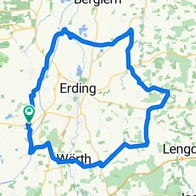
The tour primarily takes place on gravel paths and side roads to the Wildlife Park Poing, then along the railway line to Markt Schwaben and returns to the starting point via side roads (e.g., along the Isar Canal).
- -:--
- Duration
- 36.9 km
- Distance
- 107 m
- Ascent
- 87 m
- Descent
- ---
- Avg. speed
- 530 m
- Max. altitude

Route quality
Waytypes & surfaces along the route
Waytypes
Quiet road
14.8 km
(40 %)
Track
9.2 km
(25 %)
Surfaces
Paved
25.1 km
(68 %)
Unpaved
9.2 km
(25 %)
Asphalt
24.7 km
(67 %)
Gravel
8.1 km
(22 %)
Continue with Bikemap
Use, edit, or download this cycling route
You would like to ride Zum Wildpark Poing or customize it for your own trip? Here is what you can do with this Bikemap route:
Free features
- Save this route as favorite or in collections
- Copy & plan your own version of this route
- Sync your route with Garmin or Wahoo
Premium features
Free trial for 3 days, or one-time payment. More about Bikemap Premium.
- Navigate this route on iOS & Android
- Export a GPX / KML file of this route
- Create your custom printout (try it for free)
- Download this route for offline navigation
Discover more Premium features.
Get Bikemap PremiumFrom our community
Other popular routes starting in Moosinning
 Moosinning-Notzing-Niederding-Eitting-Eichenkofen-Tittenkofen-Reichenkirchen-Bockhorn-Kirchasch-Walpertskirchen-Hörlkofen-Wörth-Hofsinglding-Niederneuching-Moos
- Distance
- 51.5 km
- Ascent
- 153 m
- Descent
- 135 m
- Location
- Moosinning, Bavaria, Germany
 Waldroute bei Moosinning
- Distance
- 52.4 km
- Ascent
- 251 m
- Descent
- 251 m
- Location
- Moosinning, Bavaria, Germany
 Zum Wildpark Poing
- Distance
- 37 km
- Ascent
- 76 m
- Descent
- 74 m
- Location
- Moosinning, Bavaria, Germany
 Speichersee-Runde
- Distance
- 26.7 km
- Ascent
- 32 m
- Descent
- 22 m
- Location
- Moosinning, Bavaria, Germany
 Zum Wildpark Poing
- Distance
- 36.9 km
- Ascent
- 107 m
- Descent
- 87 m
- Location
- Moosinning, Bavaria, Germany
 Weg zur Arbeit und zurück
- Distance
- 29 km
- Ascent
- 24 m
- Descent
- 27 m
- Location
- Moosinning, Bavaria, Germany
 Moosinning-Speichersee-Kirchheim-Moosinning
- Distance
- 40.8 km
- Ascent
- 51 m
- Descent
- 48 m
- Location
- Moosinning, Bavaria, Germany
 Moosinning-Schwaig und zurück
- Distance
- 17.4 km
- Ascent
- 30 m
- Descent
- 31 m
- Location
- Moosinning, Bavaria, Germany
Open it in the app