

Chemnitz-Usedom; 2.Etappe
A cycling route starting in Bad Liebenwerda, Brandenburg, Germany.
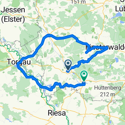
Overview
About this route
Zeischa Gruhno Doberlug-Kirchhain Sonnewalde Großkrausnick Walddrehna Gehren Zetsch Freiwalde Schönwalde Krausnick Leibsch Neuendorf Grubensee Springsee Glubigsee Wendisch-Rietz
- -:--
- Duration
- 126.9 km
- Distance
- 149 m
- Ascent
- 203 m
- Descent
- ---
- Avg. speed
- ---
- Max. altitude
Route quality
Waytypes & surfaces along the route
Waytypes
Quiet road
24.1 km
(19 %)
Road
19 km
(15 %)
Surfaces
Paved
104.1 km
(82 %)
Unpaved
12.7 km
(10 %)
Asphalt
102.8 km
(81 %)
Gravel
6.3 km
(5 %)
Continue with Bikemap
Use, edit, or download this cycling route
You would like to ride Chemnitz-Usedom; 2.Etappe or customize it for your own trip? Here is what you can do with this Bikemap route:
Free features
- Save this route as favorite or in collections
- Copy & plan your own version of this route
- Split it into stages to create a multi-day tour
- Sync your route with Garmin or Wahoo
Premium features
Free trial for 3 days, or one-time payment. More about Bikemap Premium.
- Navigate this route on iOS & Android
- Export a GPX / KML file of this route
- Create your custom printout (try it for free)
- Download this route for offline navigation
Discover more Premium features.
Get Bikemap PremiumFrom our community
Other popular routes starting in Bad Liebenwerda
 25 Jahre SUN-SPORT-TEAM die Kurze
- Distance
- 156.3 km
- Ascent
- 166 m
- Descent
- 165 m
- Location
- Bad Liebenwerda, Brandenburg, Germany
 2.Tag, Bad Liebenwerda- Cottbus
- Distance
- 103.8 km
- Ascent
- 214 m
- Descent
- 223 m
- Location
- Bad Liebenwerda, Brandenburg, Germany
 25 Jahre SUN-SPORT-TEAM - die lange Luther-Tour
- Distance
- 262.3 km
- Ascent
- 168 m
- Descent
- 170 m
- Location
- Bad Liebenwerda, Brandenburg, Germany
 50Km Liebenwerda Doberlugk Tröbitz, Rundfahrt
- Distance
- 50 km
- Ascent
- 142 m
- Descent
- 143 m
- Location
- Bad Liebenwerda, Brandenburg, Germany
 Day 3
Day 3- Distance
- 144.7 km
- Ascent
- 253 m
- Descent
- 313 m
- Location
- Bad Liebenwerda, Brandenburg, Germany
 Herrentagstour 2017 Tag 3.Samstag, 27.05. 17: Senftenberg - Bad - Liebenwerda
- Distance
- 53 km
- Ascent
- 174 m
- Descent
- 159 m
- Location
- Bad Liebenwerda, Brandenburg, Germany
 11.05.2013 Naturparktour
- Distance
- 69.8 km
- Ascent
- 193 m
- Descent
- 195 m
- Location
- Bad Liebenwerda, Brandenburg, Germany
 Landschaft von Menschenhand
- Distance
- 35.3 km
- Ascent
- 99 m
- Descent
- 99 m
- Location
- Bad Liebenwerda, Brandenburg, Germany
Open it in the app