

Capranica - Civitavecchia: la ferrovia abbandonata
A cycling route starting in Capranica, Lazio, Italy.
Overview
About this route
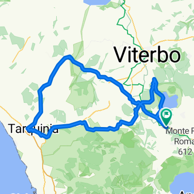
This route follows the entire abandoned railway Capranica - Civitavecchia. Considering the modest slopes to face and the good surface, the first half is suitable for those who are less trained or for those who want to 'introduce' children to MTB riding. After the Monte Romano station, the route becomes more challenging due to the presence of long tunnels and the possible presence of mud. The last 6 km are downhill on asphalt. (excerpt from the website of Paola and Gino: www.paolaegino.it)
- -:--
- Duration
- 50.2 km
- Distance
- 325 m
- Ascent
- 710 m
- Descent
- ---
- Avg. speed
- ---
- Max. altitude
Route quality
Waytypes & surfaces along the route
Waytypes
Track
38.7 km
(77 %)
Cycleway
6 km
(12 %)
Surfaces
Paved
7.5 km
(15 %)
Unpaved
32.6 km
(65 %)
Unpaved (undefined)
21.6 km
(43 %)
Asphalt
7.5 km
(15 %)
Continue with Bikemap
Use, edit, or download this cycling route
You would like to ride Capranica - Civitavecchia: la ferrovia abbandonata or customize it for your own trip? Here is what you can do with this Bikemap route:
Free features
- Save this route as favorite or in collections
- Copy & plan your own version of this route
- Sync your route with Garmin or Wahoo
Premium features
Free trial for 3 days, or one-time payment. More about Bikemap Premium.
- Navigate this route on iOS & Android
- Export a GPX / KML file of this route
- Create your custom printout (try it for free)
- Download this route for offline navigation
Discover more Premium features.
Get Bikemap PremiumFrom our community
Other popular routes starting in Capranica
 Roma -- Capranica-Civitavecchia (vecchia ferrovia)
- Distance
- 50.7 km
- Ascent
- 455 m
- Descent
- 845 m
- Location
- Capranica, Lazio, Italy
 Capranica - Civitavecchia: la ferrovia abbandonata
- Distance
- 50.2 km
- Ascent
- 325 m
- Descent
- 710 m
- Location
- Capranica, Lazio, Italy
 reitsma route
- Distance
- 2,126.2 km
- Ascent
- 469 m
- Descent
- 1,072 m
- Location
- Capranica, Lazio, Italy
 Ferrovia Capranica-Civitavecchia
- Distance
- 49.9 km
- Ascent
- 311 m
- Descent
- 704 m
- Location
- Capranica, Lazio, Italy
 Monti Cimini e Tuscia 2
- Distance
- 122.5 km
- Ascent
- 1,210 m
- Descent
- 1,220 m
- Location
- Capranica, Lazio, Italy
 Capranica - Sutri - Capranica
- Distance
- 12.6 km
- Ascent
- 151 m
- Descent
- 149 m
- Location
- Capranica, Lazio, Italy
 Ferrovia abbandonata Capranica Civitavecchia
- Distance
- 48.5 km
- Ascent
- 310 m
- Descent
- 690 m
- Location
- Capranica, Lazio, Italy
 Monte Fogliano
- Distance
- 10.9 km
- Ascent
- 596 m
- Descent
- 9 m
- Location
- Capranica, Lazio, Italy
Open it in the app