VASCO NAVARRO ESTIBALIZ
- 14.2 km
- 747 m
- 270 m
- Vitoria-Gasteiz, Basque Country, Spain
A cycling route starting in Vitoria-Gasteiz, Basque Country, Spain.
Overview
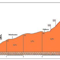
Nº 1 - Excursion 2013 - Vitoria-Gasteiz – Parque Molinuevo - Abechuco – Echevarri-Viña – Gopegi - Murgia – Amézaga - Goiuri-Ondona – Orduña – Cumbre Pto. Orduña – vuelta Orduña – Pto. Barrerilla - Goirui-Ondona – Izarra – Abornikano – Catadiano - Loma de Ganalto – A-4310 – A-3302 - Los Huetos Hiribidea – Adriano VI – Domingo Beltran – Coronation of the Virgin. 1st - Pto. de Orduña Average slope 7.62% - Max slope 14% - 7.9 km of ascent. 2nd - Pto. La Barrerilla Average slope 5.4% - Max slope 7.1% - 6.6 km of ascent. 3rd - Loma de Ganalto Average slope 7% - 3.5 km of ascent
created this 12 years ago
Route highlights
1º - Pto. de Orduña Pendiente media 7,62% - Pendiente máx 14% - 7,9 Km. de ascensión.
2º - Pto. La Barrerilla Pendiente media 5,4% - Pendiente máx 7,1% - 6,6 Km. de ascensión
3º - Loma de Ganalto Pendiente media 7% - 3,5 Km. de ascensión.
Continue with Bikemap
You would like to ride 2013 (Excursión - Vitoria-Gasteiz) or customize it for your own trip? Here is what you can do with this Bikemap route:
Free trial for 3 days, or one-time payment. More about Bikemap Premium.
Discover more Premium features.
Get Bikemap PremiumFrom our community
Open it in the app