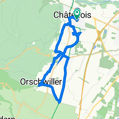
Châtenois - Champ du Feu
A cycling route starting in Châtenois, Alsace-Champagne-Ardenne-Lorraine, France.
Overview
About this route
vom Elsass in die Vogesen
- -:--
- Duration
- 43.9 km
- Distance
- 1,223 m
- Ascent
- 308 m
- Descent
- ---
- Avg. speed
- ---
- Max. altitude
Route highlights
Points of interest along the route
Point of interest after 7.5 km
Continue with Bikemap
Use, edit, or download this cycling route
You would like to ride Châtenois - Champ du Feu or customize it for your own trip? Here is what you can do with this Bikemap route:
Free features
- Save this route as favorite or in collections
- Copy & plan your own version of this route
- Sync your route with Garmin or Wahoo
Premium features
Free trial for 3 days, or one-time payment. More about Bikemap Premium.
- Navigate this route on iOS & Android
- Export a GPX / KML file of this route
- Create your custom printout (try it for free)
- Download this route for offline navigation
Discover more Premium features.
Get Bikemap PremiumFrom our community
Other popular routes starting in Châtenois
- Sechs Pässe
- Distance
- 136 km
- Ascent
- 1,999 m
- Descent
- 1,999 m
- Location
- Châtenois, Alsace-Champagne-Ardenne-Lorraine, France
- P2018-J2d-Châtenois - canal Rhône-Rhin- Châtenois
- Distance
- 46.3 km
- Ascent
- 67 m
- Descent
- 67 m
- Location
- Châtenois, Alsace-Champagne-Ardenne-Lorraine, France
- selestat
- Distance
- 78.5 km
- Ascent
- 1,207 m
- Descent
- 1,209 m
- Location
- Châtenois, Alsace-Champagne-Ardenne-Lorraine, France
- Chatenois-Haut Koenigsbourg-Altenberg
- Distance
- 39.6 km
- Ascent
- 1,227 m
- Descent
- 1,224 m
- Location
- Châtenois, Alsace-Champagne-Ardenne-Lorraine, France
- FR1-16_Chatenois - Strasbourg_74,0km 380hm
- Distance
- 74.1 km
- Ascent
- 468 m
- Descent
- 516 m
- Location
- Châtenois, Alsace-Champagne-Ardenne-Lorraine, France
- P2018-J2_Châtenois-Canal-Rhin-Châtenois
- Distance
- 68.5 km
- Ascent
- 89 m
- Descent
- 89 m
- Location
- Châtenois, Alsace-Champagne-Ardenne-Lorraine, France
- P2018-J1_Châtenois-Colmar-Châtenois
- Distance
- 60.5 km
- Ascent
- 87 m
- Descent
- 90 m
- Location
- Châtenois, Alsace-Champagne-Ardenne-Lorraine, France
- Châtenois - Champ du Feu
- Distance
- 43.9 km
- Ascent
- 1,223 m
- Descent
- 308 m
- Location
- Châtenois, Alsace-Champagne-Ardenne-Lorraine, France
Open it in the app