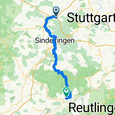
Enztal und Schwarzwald
A cycling route starting in Leonberg, Baden-Wurttemberg, Germany.
Overview
About this route
Test route: hilly towards Mühlacker, through the Würm valley and along the first Black Forest ridge back to Leo
- -:--
- Duration
- 102.9 km
- Distance
- 1,122 m
- Ascent
- 1,122 m
- Descent
- ---
- Avg. speed
- ---
- Max. altitude
Route quality
Waytypes & surfaces along the route
Waytypes
Road
39.1 km
(38 %)
Quiet road
15.4 km
(15 %)
Surfaces
Paved
97.7 km
(95 %)
Unpaved
1 km
(1 %)
Asphalt
97.7 km
(95 %)
Ground
1 km
(1 %)
Undefined
4.1 km
(4 %)
Route highlights
Points of interest along the route
Point of interest after 93.6 km
50m Schotter über Brücke
Point of interest after 93.6 km
Continue with Bikemap
Use, edit, or download this cycling route
You would like to ride Enztal und Schwarzwald or customize it for your own trip? Here is what you can do with this Bikemap route:
Free features
- Save this route as favorite or in collections
- Copy & plan your own version of this route
- Split it into stages to create a multi-day tour
- Sync your route with Garmin or Wahoo
Premium features
Free trial for 3 days, or one-time payment. More about Bikemap Premium.
- Navigate this route on iOS & Android
- Export a GPX / KML file of this route
- Create your custom printout (try it for free)
- Download this route for offline navigation
Discover more Premium features.
Get Bikemap PremiumFrom our community
Other popular routes starting in Leonberg
- Leo - Sifi - Renningen - Leo
- Distance
- 30.7 km
- Ascent
- 404 m
- Descent
- 415 m
- Location
- Leonberg, Baden-Wurttemberg, Germany
- Sabine Leonberg
- Distance
- 49.3 km
- Ascent
- 480 m
- Descent
- 480 m
- Location
- Leonberg, Baden-Wurttemberg, Germany
- Rund um Leonberg
- Distance
- 39.6 km
- Ascent
- 415 m
- Descent
- 415 m
- Location
- Leonberg, Baden-Wurttemberg, Germany
- Rutesheim - Schillerhöhe
- Distance
- 27.2 km
- Ascent
- 304 m
- Descent
- 304 m
- Location
- Leonberg, Baden-Wurttemberg, Germany
- Über die Feinau
- Distance
- 27.4 km
- Ascent
- 326 m
- Descent
- 326 m
- Location
- Leonberg, Baden-Wurttemberg, Germany
- Brauhaus-Tour
- Distance
- 21.4 km
- Ascent
- 210 m
- Descent
- 99 m
- Location
- Leonberg, Baden-Wurttemberg, Germany
- Tour de Natur 2012
- Distance
- 27.2 km
- Ascent
- 212 m
- Descent
- 209 m
- Location
- Leonberg, Baden-Wurttemberg, Germany
- Leonberg Tour de Natur 2008-Final
- Distance
- 35.6 km
- Ascent
- 335 m
- Descent
- 278 m
- Location
- Leonberg, Baden-Wurttemberg, Germany
Open it in the app