

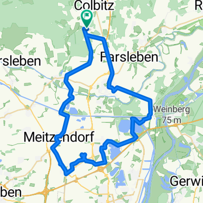
Kleine Heiderunde
A cycling route starting in Colbitz, Saxony-Anhalt, Germany.
Overview
About this route
Nice woodland loop, partly on unpaved roads. Along the route you'll pass the monument marking the opening of the Jägerstieg trail. Refreshment options: huts and Haus Humbertus
- -:--
- Duration
- 27.4 km
- Distance
- 145 m
- Ascent
- 145 m
- Descent
- ---
- Avg. speed
- ---
- Max. altitude
Route highlights
Points of interest along the route

Point of interest after 7 km
Continue with Bikemap
Use, edit, or download this cycling route
You would like to ride Kleine Heiderunde or customize it for your own trip? Here is what you can do with this Bikemap route:
Free features
- Save this route as favorite or in collections
- Copy & plan your own version of this route
- Sync your route with Garmin or Wahoo
Premium features
Free trial for 3 days, or one-time payment. More about Bikemap Premium.
- Navigate this route on iOS & Android
- Export a GPX / KML file of this route
- Create your custom printout (try it for free)
- Download this route for offline navigation
Discover more Premium features.
Get Bikemap PremiumFrom our community
Other popular routes starting in Colbitz
 Kleine Heiderunde
- Distance
- 27.4 km
- Ascent
- 145 m
- Descent
- 145 m
- Location
- Colbitz, Saxony-Anhalt, Germany
 Lindhorst - Colbitz - Angern - Sandkrug - Rogätz - Loitsche - Zielitz - Schricke - Lindhorst
- Distance
- 41.2 km
- Ascent
- 114 m
- Descent
- 114 m
- Location
- Colbitz, Saxony-Anhalt, Germany
 Im Winkel, Colbitz nach Veerßer Straße, Uelzen
- Distance
- 152.2 km
- Ascent
- 316 m
- Descent
- 331 m
- Location
- Colbitz, Saxony-Anhalt, Germany
 Lindhorst - Wolmirstedt - Glindenberg - Farsleber See - Barleben - Jersleben - Samswegen - Lindhorst
- Distance
- 45.3 km
- Ascent
- 78 m
- Descent
- 75 m
- Location
- Colbitz, Saxony-Anhalt, Germany
 Im Winkel, Colbitz nach Parduin, Brandenburg an der Havel
- Distance
- 84.5 km
- Ascent
- 192 m
- Descent
- 213 m
- Location
- Colbitz, Saxony-Anhalt, Germany
 Lindhorst - Meseberg - Samswegen - Wolmirstedt - Heinrichsberg - Loitsche - Zielitz - Schricke - Colbitz - Lindhorst
- Distance
- 41.7 km
- Ascent
- 104 m
- Descent
- 104 m
- Location
- Colbitz, Saxony-Anhalt, Germany
 Lindhorst - Jägerstieg - Rabensol - Lindenwald - Colbitz - Lindhorst
- Distance
- 18.2 km
- Ascent
- 69 m
- Descent
- 72 m
- Location
- Colbitz, Saxony-Anhalt, Germany
 Lindhorst - Vahldorf - Jersleben - Wolmirstedt - Lindhorst
- Distance
- 35.5 km
- Ascent
- 68 m
- Descent
- 68 m
- Location
- Colbitz, Saxony-Anhalt, Germany
Open it in the app