

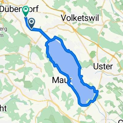
Weisslingen - Pfäffikon - Forch
A cycling route starting in Fällanden, Canton of Zurich, Switzerland.
Overview
About this route
No special remarks
- -:--
- Duration
- 55.4 km
- Distance
- 699 m
- Ascent
- 564 m
- Descent
- ---
- Avg. speed
- 689 m
- Max. altitude
Route quality
Waytypes & surfaces along the route
Waytypes
Road
21 km
(38 %)
Path
10 km
(18 %)
Surfaces
Paved
51.5 km
(93 %)
Unpaved
0.6 km
(1 %)
Asphalt
51.5 km
(93 %)
Unpaved (undefined)
0.6 km
(1 %)
Undefined
3.3 km
(6 %)
Continue with Bikemap
Use, edit, or download this cycling route
You would like to ride Weisslingen - Pfäffikon - Forch or customize it for your own trip? Here is what you can do with this Bikemap route:
Free features
- Save this route as favorite or in collections
- Copy & plan your own version of this route
- Sync your route with Garmin or Wahoo
Premium features
Free trial for 3 days, or one-time payment. More about Bikemap Premium.
- Navigate this route on iOS & Android
- Export a GPX / KML file of this route
- Create your custom printout (try it for free)
- Download this route for offline navigation
Discover more Premium features.
Get Bikemap PremiumFrom our community
Other popular routes starting in Fällanden
 Fä - Ar I
- Distance
- 12.2 km
- Ascent
- 88 m
- Descent
- 57 m
- Location
- Fällanden, Canton of Zurich, Switzerland
 Weisslingen - Pfäffikon - Forch
- Distance
- 55.4 km
- Ascent
- 699 m
- Descent
- 564 m
- Location
- Fällanden, Canton of Zurich, Switzerland
 2) Fällanden - Forch - Pfannenstiel - Oetwil a.S. - Gossau - Uster - Fällanden
- Distance
- 46.6 km
- Ascent
- 614 m
- Descent
- 622 m
- Location
- Fällanden, Canton of Zurich, Switzerland
 Sinnvolle Mittagspause #1
- Distance
- 43.7 km
- Ascent
- 475 m
- Descent
- 475 m
- Location
- Fällanden, Canton of Zurich, Switzerland
 Fällanden - Walensee - Sargans - Alt St. Johann - Sternenberg - Volketswil Fällanden
- Distance
- 199.9 km
- Ascent
- 2,505 m
- Descent
- 2,330 m
- Location
- Fällanden, Canton of Zurich, Switzerland
 Sinnvolle Mittagspause #6
- Distance
- 62.9 km
- Ascent
- 780 m
- Descent
- 779 m
- Location
- Fällanden, Canton of Zurich, Switzerland
 25km Marsch RS 2/24
- Distance
- 25 km
- Ascent
- 274 m
- Descent
- 271 m
- Location
- Fällanden, Canton of Zurich, Switzerland
 3) Fällanden - Forch - Pfannenstiel - Maur - Fällanden
- Distance
- 29.8 km
- Ascent
- 509 m
- Descent
- 514 m
- Location
- Fällanden, Canton of Zurich, Switzerland
Open it in the app