

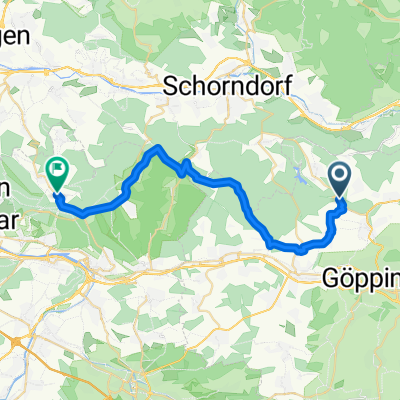
Börtlingen - Berkheim
A cycling route starting in Börtlingen, Baden-Wurttemberg, Germany.
Overview
About this route
Strecke mit einem Peak am Anfang und am Ende. Dazwischen weitgehend flach.
- -:--
- Duration
- 37.9 km
- Distance
- 319 m
- Ascent
- 435 m
- Descent
- ---
- Avg. speed
- 467 m
- Max. altitude

Route quality
Waytypes & surfaces along the route
Waytypes
Busy road
14.1 km
(37 %)
Quiet road
10.7 km
(28 %)
Surfaces
Paved
34.7 km
(92 %)
Unpaved
0.2 km
(<1 %)
Asphalt
31.8 km
(84 %)
Paved (undefined)
2.7 km
(7 %)
Continue with Bikemap
Use, edit, or download this cycling route
You would like to ride Börtlingen - Berkheim or customize it for your own trip? Here is what you can do with this Bikemap route:
Free features
- Save this route as favorite or in collections
- Copy & plan your own version of this route
- Sync your route with Garmin or Wahoo
Premium features
Free trial for 3 days, or one-time payment. More about Bikemap Premium.
- Navigate this route on iOS & Android
- Export a GPX / KML file of this route
- Create your custom printout (try it for free)
- Download this route for offline navigation
Discover more Premium features.
Get Bikemap PremiumFrom our community
Other popular routes starting in Börtlingen
 Zachersmühle, Adelberg nach Kantstraße, Aichwald
- Distance
- 27.8 km
- Ascent
- 524 m
- Descent
- 420 m
- Location
- Börtlingen, Baden-Wurttemberg, Germany
 Birenbach-Wäschenbeuren
- Distance
- 18.8 km
- Ascent
- 186 m
- Descent
- 185 m
- Location
- Börtlingen, Baden-Wurttemberg, Germany
 Zeller Straße 15, Börtlingen nach Albstraße 25, Börtlingen
- Distance
- 36.4 km
- Ascent
- 710 m
- Descent
- 711 m
- Location
- Börtlingen, Baden-Wurttemberg, Germany
 Börtlingen - Hohenstaufen Rennerrunde
- Distance
- 29.9 km
- Ascent
- 424 m
- Descent
- 484 m
- Location
- Börtlingen, Baden-Wurttemberg, Germany
 Aufnahme vom 13. August, 14:52
- Distance
- 3.5 km
- Ascent
- 157 m
- Descent
- 44 m
- Location
- Börtlingen, Baden-Wurttemberg, Germany
 Waldhausen - Gingen / Brenz
- Distance
- 80.3 km
- Ascent
- 559 m
- Descent
- 375 m
- Location
- Börtlingen, Baden-Wurttemberg, Germany
 Börtlingen - Berkheim
- Distance
- 37.9 km
- Ascent
- 319 m
- Descent
- 435 m
- Location
- Börtlingen, Baden-Wurttemberg, Germany
 Börtlingen - Hohenstadt
- Distance
- 110.1 km
- Ascent
- 1,629 m
- Descent
- 1,654 m
- Location
- Börtlingen, Baden-Wurttemberg, Germany
Open it in the app