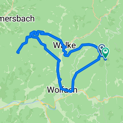
Schömberrunde
A cycling route starting in Oberwolfach, Baden-Wurttemberg, Germany.
Overview
About this route
- -:--
- Duration
- 65.4 km
- Distance
- 1,712 m
- Ascent
- 1,653 m
- Descent
- ---
- Avg. speed
- 850 m
- Max. altitude
Route quality
Waytypes & surfaces along the route
Waytypes
Path
3.3 km
(5 %)
Track
2.6 km
(4 %)
Surfaces
Paved
56.2 km
(86 %)
Unpaved
2 km
(3 %)
Asphalt
56.2 km
(86 %)
Unpaved (undefined)
2 km
(3 %)
Undefined
7.2 km
(11 %)
Continue with Bikemap
Use, edit, or download this cycling route
You would like to ride Schömberrunde or customize it for your own trip? Here is what you can do with this Bikemap route:
Free features
- Save this route as favorite or in collections
- Copy & plan your own version of this route
- Sync your route with Garmin or Wahoo
Premium features
Free trial for 3 days, or one-time payment. More about Bikemap Premium.
- Navigate this route on iOS & Android
- Export a GPX / KML file of this route
- Create your custom printout (try it for free)
- Download this route for offline navigation
Discover more Premium features.
Get Bikemap PremiumFrom our community
Other popular routes starting in Oberwolfach
Schömberrunde- Distance
- 65.4 km
- Ascent
- 1,712 m
- Descent
- 1,653 m
- Location
- Oberwolfach, Baden-Wurttemberg, Germany
Gipfelstürmer- Distance
- 46.7 km
- Ascent
- 1,247 m
- Descent
- 1,247 m
- Location
- Oberwolfach, Baden-Wurttemberg, Germany
BF24-07 Oberwolfach - Schramberg 83 KM- Distance
- 83.1 km
- Ascent
- 1,699 m
- Descent
- 1,700 m
- Location
- Oberwolfach, Baden-Wurttemberg, Germany
Hansjakobweg nach Hansjakobweg- Distance
- 38.6 km
- Ascent
- 1,314 m
- Descent
- 1,326 m
- Location
- Oberwolfach, Baden-Wurttemberg, Germany
BF24-09 Oberwoldfach - Rohrhardsberg über Yach 104 KM- Distance
- 103.8 km
- Ascent
- 2,307 m
- Descent
- 2,309 m
- Location
- Oberwolfach, Baden-Wurttemberg, Germany
BF24-06 Oberwolfach - Bad-Peterstal 72 KM- Distance
- 71.8 km
- Ascent
- 1,620 m
- Descent
- 1,620 m
- Location
- Oberwolfach, Baden-Wurttemberg, Germany
BF24-02 Oberwolfach - Schweighausen 83KM- Distance
- 83.2 km
- Ascent
- 1,027 m
- Descent
- 1,029 m
- Location
- Oberwolfach, Baden-Wurttemberg, Germany
BF24-04 Oberwolfach - Sulz a. Neckar - 108 KM- Distance
- 107.7 km
- Ascent
- 1,503 m
- Descent
- 1,502 m
- Location
- Oberwolfach, Baden-Wurttemberg, Germany
Open it in the app

