

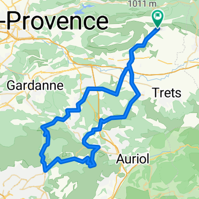
1_Puyloubier > Aix-Trets-Pourcieux
A cycling route starting in Puyloubier, Provence-Alpes-Côte d'Azur Region, France.
Overview
About this route
- -:--
- Duration
- 59.6 km
- Distance
- 388 m
- Ascent
- 388 m
- Descent
- ---
- Avg. speed
- ---
- Max. altitude
Route quality
Waytypes & surfaces along the route
Waytypes
Road
22.6 km
(38 %)
Quiet road
10.7 km
(18 %)
Surfaces
Paved
30.4 km
(51 %)
Asphalt
30.4 km
(51 %)
Undefined
29.2 km
(49 %)
Continue with Bikemap
Use, edit, or download this cycling route
You would like to ride 1_Puyloubier > Aix-Trets-Pourcieux or customize it for your own trip? Here is what you can do with this Bikemap route:
Free features
- Save this route as favorite or in collections
- Copy & plan your own version of this route
- Sync your route with Garmin or Wahoo
Premium features
Free trial for 3 days, or one-time payment. More about Bikemap Premium.
- Navigate this route on iOS & Android
- Export a GPX / KML file of this route
- Create your custom printout (try it for free)
- Download this route for offline navigation
Discover more Premium features.
Get Bikemap PremiumFrom our community
Other popular routes starting in Puyloubier
 De D10, Vauvenargues à 805 Chemin des Vérans, Saint-Marc-Jaumegarde
- Distance
- 8.2 km
- Ascent
- 128 m
- Descent
- 124 m
- Location
- Puyloubier, Provence-Alpes-Côte d'Azur Region, France
 Puyloubier - Méounes
- Distance
- 46.9 km
- Ascent
- 348 m
- Descent
- 445 m
- Location
- Puyloubier, Provence-Alpes-Côte d'Azur Region, France
 2_Puyloubier > SudOuest: Allauch-Peynier-Puyloubier
- Distance
- 75.1 km
- Ascent
- 1,007 m
- Descent
- 1,016 m
- Location
- Puyloubier, Provence-Alpes-Côte d'Azur Region, France
 De Avenue Cézanne, Puyloubier à Route de Rians, Pourrières
- Distance
- 12.1 km
- Ascent
- 226 m
- Descent
- 97 m
- Location
- Puyloubier, Provence-Alpes-Côte d'Azur Region, France
 Val de l'Arc
- Distance
- 44 km
- Ascent
- 422 m
- Descent
- 422 m
- Location
- Puyloubier, Provence-Alpes-Côte d'Azur Region, France
 18_Puyloubier > Est
- Distance
- 49.6 km
- Ascent
- 455 m
- Descent
- 446 m
- Location
- Puyloubier, Provence-Alpes-Côte d'Azur Region, France
 Circuit Sainte-Victoire pour dim 13/07
- Distance
- 69.9 km
- Ascent
- 859 m
- Descent
- 859 m
- Location
- Puyloubier, Provence-Alpes-Côte d'Azur Region, France
 216 Chemin Philippe Noclercq, Puyloubier à 4259 Route des Pinchinats, Aix-en-Provence
- Distance
- 67 km
- Ascent
- 1,611 m
- Descent
- 1,614 m
- Location
- Puyloubier, Provence-Alpes-Côte d'Azur Region, France
Open it in the app