
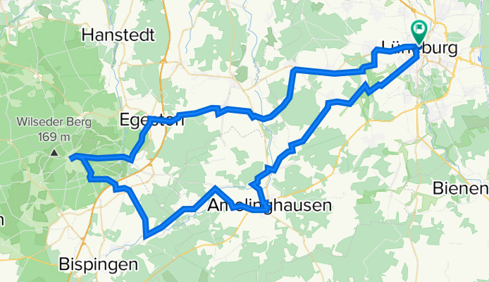
Lüneburger Heidetour
A cycling route starting in Lüneburg, Lower Saxony, Germany.
Overview
About this route
<span style="font-size: small;"><font color="#000000"><font face="Calibri">Höhepunkte der Heide Tour:</font></font></span>
<span style="font-size: small;"><font color="#000000"><font face="Calibri">Startpunkt: Tourist-Information Lüneburg</font></font></span>
<span style="font-size: small;"><font color="#000000"><font face="Calibri">Das Naturschutzgebiet Lüneburger Heide ist das älteste<font size="3"> </font>und eines der größten Deutschlands. Auf dieser</font></font></span>
<span style="font-size: small;"><font color="#000000"><font face="Calibri">Tour können Sie die für die<font size="3"> </font>Lüne- burger Heide typische<font size="3"> </font>Landschaft mit all ihren Facetten entdecken: weite<font size="3"> </font>Heideflächen umgeben von Wäldern und Mooren, ein nur leicht</font></font></span>
<span style="font-size: small;"><font color="#000000"><font face="Calibri">hügeliges Gelände, ideal zum Rad- fahren. Viele Flüsse und Seen<font size="3"> </font>bieten eine Abwechslung zu den blühenden Heideflächen und<font size="3"> </font>satt- grünen Wäldern, die Sandböden sind gut befahrbar.<font size="3"> </font></font></font></span>
<span style="font-size: small;"><font color="#000000"><font face="Calibri">Amelinghausen: In dem 700 Jahre alten Heideort findet jedes<font size="3"> </font>Jahr im August eines der größten Heideblütenfeste der Region<font size="3"> </font>statt. Sehenswert is<font size="3">t </font>außerdem die Oldendorfer Totenstatt, eines<font size="3"> </font>der inte- ressantesten Steingräber im<font size="3"> </font>Land- kreis Lüneburg.<font size="3"> </font>Weitere Infos unter: www.amelinghausen.de</font></font></span>
<span style="font-size: small;"><font color="#000000"><font face="Calibri">Egestorf: Den Ortsmittelpunkt bildet die St.-Stephanus-Kirche</font></font></span>
<span style="font-size: small;"><font color="#000000"><font face="Calibri">aus dem Jahre 1645 mit einer schöner Gartenanlage, eine<font size="3"> </font>Fach- werk-</font></font></span><span style="font-size: small;"><font color="#000000"><font face="Calibri">Kirche mit abseits stehendem hölzernen Glockenturm, die </font></font></span><span style="font-size: small;"><font color="#000000"><font face="Calibri">an die nordischen Stabkirchen erinnert. Im Inneren ist ein reich<font size="3"> </font>mit Statuetten und Bildern geschmückte<font size="3">n </font>Altar- aufsatz zu besichtigen.<font size="3"> </font>Auf dem Dorfplatz vor der Kirche finden Sie eine Büste de<font size="3">s </font>Heidepastors Wilhelm Bode. Der Begründer des Naturschutzgebiets<font size="3"> </font>Lüneburger Heide lebte und wirkte hier von 1886 bis<font size="3"> </font>1923. Ihm ist es zu verdanken, dass ein Teil der Heidelandschaft<font size="3"> </font>für die Nachwelt erhalten blieb.</font></font></span>
<span style="font-size: small;"><font color="#000000"><font face="Calibri">Wilseder Berg: Entstanden ist die Erhebung während der vorletzten</font></font></span>
<span style="font-size: small;"><font color="#000000"><font face="Calibri">Eiszeit, der Saaleeiszeit; es handelt sich dabei um einen Teil<font size="3"> </font>einer Endmoräne. Der Wilseder Berg bildet die höchste Erhebung<font size="3"> </font>Nord- deutschlands mit 169,2 m und das Zentrum der größten<font size="3"> </font>Heideflächen</font></font></span>
<span style="font-size: small;"><font color="#000000"><font face="Calibri">Europas. Einmalig ist der Blick über die blühende<font size="3"> </font>Landschaft mit ihren charakteristische<font size="3">n </font>Wacholder- büschen.</font></font></span>
- -:--
- Duration
- 86.9 km
- Distance
- 340 m
- Ascent
- 338 m
- Descent
- ---
- Avg. speed
- ---
- Max. altitude

Route quality
Waytypes & surfaces along the route
Waytypes
Quiet road
33.6 km
(39 %)
Road
23.3 km
(27 %)
Surfaces
Paved
70 km
(81 %)
Unpaved
9.4 km
(11 %)
Asphalt
60.6 km
(70 %)
Paving stones
5.1 km
(6 %)
Route highlights
Points of interest along the route
Point of interest after 0.4 km
Parkhaus am Graalwall
Point of interest after 0.8 km
Bus und PKW Parkplatz An den Sülwiesen Anfahrt Sülzwiesen Stellplätze 450 Lage City-Nähe: 7 Min Öffnungszeiten: 24 Stunden durchgehend geöffnet Höchstparkdauer unbegrenzt Kosten keine
Point of interest after 6.6 km
Waldhof Böhmsholz Biergarten / Spielplatz
Point of interest after 39.5 km
Point of interest after 42.8 km
Holzschild nach Hörpel folgen
Point of interest after 63.7 km
Parkplatz
Point of interest after 63.8 km
Parkplatz auch Für Wohnwagen und Wohnmobile
Point of interest after 86.6 km
Parkhaus Neue Sülze
Continue with Bikemap
Use, edit, or download this cycling route
You would like to ride Lüneburger Heidetour or customize it for your own trip? Here is what you can do with this Bikemap route:
Free features
- Save this route as favorite or in collections
- Copy & plan your own version of this route
- Split it into stages to create a multi-day tour
- Sync your route with Garmin or Wahoo
Premium features
Free trial for 3 days, or one-time payment. More about Bikemap Premium.
- Navigate this route on iOS & Android
- Export a GPX / KML file of this route
- Create your custom printout (try it for free)
- Download this route for offline navigation
Discover more Premium features.
Get Bikemap PremiumFrom our community
Other popular routes starting in Lüneburg
 Alte Salzstraße
- Distance
- 92.1 km
- Ascent
- 100 m
- Descent
- 106 m
- Location
- Lüneburg, Lower Saxony, Germany
 Lüneburg (Tour II)
- Distance
- 30.7 km
- Ascent
- 88 m
- Descent
- 88 m
- Location
- Lüneburg, Lower Saxony, Germany
 immer geradeaus
- Distance
- 40.6 km
- Ascent
- 186 m
- Descent
- 165 m
- Location
- Lüneburg, Lower Saxony, Germany
 Die Hitzacker Runde
- Distance
- 138.7 km
- Ascent
- 364 m
- Descent
- 365 m
- Location
- Lüneburg, Lower Saxony, Germany
 Lüneburg: Lüneburger Backsteintour (Tagestour 20 km)
- Distance
- 19.7 km
- Ascent
- 0 m
- Descent
- 0 m
- Location
- Lüneburg, Lower Saxony, Germany
 Heidetour (ab/bis Lüneburg)
- Distance
- 89.8 km
- Ascent
- 337 m
- Descent
- 336 m
- Location
- Lüneburg, Lower Saxony, Germany
 Lüneburg (21,1 km)
- Distance
- 21.6 km
- Ascent
- 98 m
- Descent
- 99 m
- Location
- Lüneburg, Lower Saxony, Germany
 2018 Printentour 3/3 Lüneburg Bramfeld
- Distance
- 67.7 km
- Ascent
- 71 m
- Descent
- 75 m
- Location
- Lüneburg, Lower Saxony, Germany
Open it in the app